
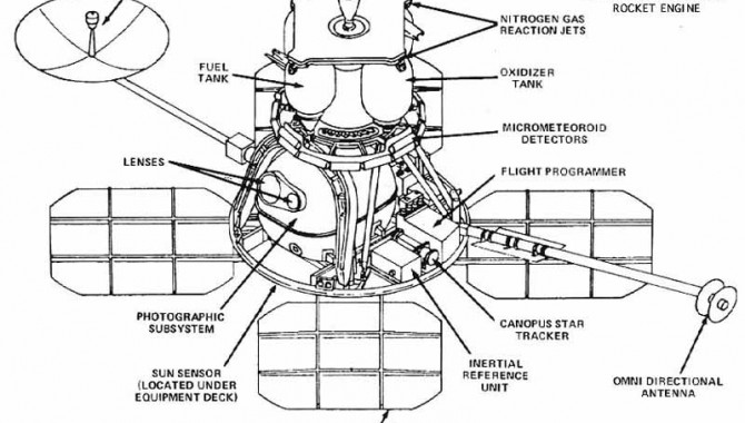
Lunar Orbiter spacecraft schematic as seen in Destination Moon: A History of the Lunar Orbiter Program. Image Credit: NASA
August 30, 2012 Vol. 5, Issue 8
The 3,000-plus images captured by the Lunar Orbiter Program from August 1966-August 1967 were critical in paving the way for the first manned flight to the Moon.
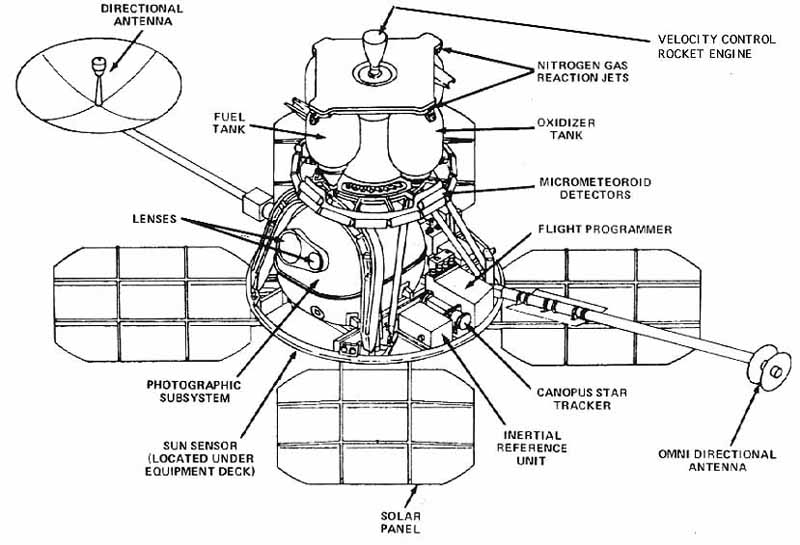
Lunar Orbiter spacecraft schematic as seen in Destination Moon: A History of the Lunar Orbiter Program.
Image Credit: NASA
The original vision for a lunar orbiter was to better understand the origin of Earth by exploring Earths only satellite, the Moon. But difficulties with the Ranger Program (conceived to gather close-up images of the lunar surface) combined with growing pressure to deliver a manned spacecraft to the Moon refocused the programs objectives. With the Apollo Program imminent, NASA was faced with an urgent need for a clear map of the lunar surface to prepare for manned landings. The Apollo Program required photographs of the lunar surface that were detailed down to 1 meter, depicting relatively small protuberances and depressions on the Moon’s near side.
In 1963, NASA began working with Boeing to develop the Lunar Orbiter. It was a bold move: Boeing, better known for building aircraft, had never managed a major NASA space flight program. Yet Boeing’s plan to incorporate existing hardware and technology would streamline the design and development process so that the Lunar Orbiter Program could meet tight timelines dictated by the Apollo Program’s needs.

The world’s first view of Earth as released to the public taken by a spacecraft within the vicinity of the Moon. The photo was transmitted to Earth by the United States Lunar Orbiter I and received at the NASA tracking station at Robledo De Chavela near Madrid, Spain. This crescent of the Earth was photographed August 23, 1966 at 16:35 GMT when the spacecraft was on its 16th orbit and just about to pass behind the Moon.
Image Credit: NASA/Lunar Orbiter Image Recovery Project
Boeing’s design and development plan wasn’t its only appeal. Their proposal included a photographic system created by Eastman Kodak that had already been proven in military applications. The system would handle film processing on board—using existing technology—so that photographic images could be transmitted to Earth from the spacecraft. The system featured a dual-lens camera, with one lens providing high-resolution images while the other offered medium-resolution photographs. This gave the camera the ability to serve two purposes simultaneously: photographing a vast area of lunar surface while providing highly detailed images. In fact, the system was able to photograph areas as large as 8,000 square kilometers in high-resolution mode—four times the size of area originally specified by NASA. As a backup measure, if one camera lens failed, the mission wouldn’t be a loss as the second lens would still capture data. Furthermore, the low-resolution film used for the Lunar Orbiter wouldn’t be vulnerable to interference from solar radiation.
In addition to capturing detailed photographic data about the Moon’s surface, the program had several important secondary objectives in the form of scientific experiments. The first experiment was designed to study the topography of the lunar surface, which would further help select an appropriate landing site for manned missions. The second was to examine meteoroid impacts, which would support the Apollo Program in determining the degree of protection needed for spacesuits, instruments, and spacecraft. The final experiment was to measure radiation levels. This was critical for Apollo, as it would help scientists understand how much radiation astronauts should expect, both in the Lunar Module and in space suits.
Lunar Orbiter I launched on August 10, 1966. The success of the mission was threatened twice: first the Canopus star navigation system failed, then the spacecraft overheated. Both problems proved manageable. Mission navigation was achieved by using the Moon as a reference while overheating diminished when the craft was oriented 36 degrees off-Sun. Lunar Orbiter I was injected into a near-equatorial lunar orbit approximately 92 hours after launch. The spacecraft took photographs from August 18-29, producing 42 high-resolution and 197 medium-resolution images. Altogether, the photographs covered more than 5 million square kilometers of lunar surface. The spacecraft also acquired accurate data from its other experiments. But Lunar Orbiter I may be best known for taking the first two pictures of Earth from lunar orbit. Once the images were transmitted, people saw their planet from the perspective of its satellite for the first time.

Launch of Lunar Orbiter 1.
Photo Credit: NASA
Lunar Orbiter II and III, launched on November 6, 1966 and February 5, 1967 respectively, shared the same primary mission as Lunar Orbiter I: to survey potential landing sites for the Apollo Program. Lunar Orbiters IV and V had slightly different objectives. Launched on May 4, 1967, Lunar Orbiter IV surveyed broader lunar surface features to expand scientific knowledge. Lunar Orbiter V, which left Cape Canaveral on August 1, 1967, photographed potential landing sites as well as the far side of the Moon.
All five Lunar Orbiter missions were successful. Throughout their extended orbits, the Lunar Orbiter spacecraft photographed 99% of the Moon’s surface (all of its near side and 95% of its far side) and produced a total of 3,062 images. The information from the Lunar Orbiter program contributed meaningfully to the success of the Apollo Program by providing crucial information about possible landing sites. In addition, the program offered the Manned Space Flight Network a unique opportunity to train personnel in spacecraft tracking, equipment management, and computer programming, knowledge that directly benefitted the Apollo Program.
As the first successful NASA venture to map terrain beyond Earth, what was learned from the Lunar Orbiter program resonate far beyond the Apollo Program. The photographs supported future Surveyor Lander missions. Technical understanding from the program informed the 1970’s Viking program, which mapped the surface of Mars, and echoes in Mars Odyssey’s terrain-mapping efforts. The Lunar Orbiter Program produced two additional “firsts” for NASA: it was the first significant deep space project for Langley Research Center as well as NASA’s first foray into incentive-based contracting.
To learn more, read Bruce K. Byers’ A History of the Lunar Orbiter Program.