July 30, 2010 Vol. 3, Issue 7
With the launch of TanDEM-X, the German Aerospace Center (DLR) is taking space-borne synthetic aperture radar to the next level.

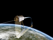
TanDEM-X and TerraSAR-X flying in formation. (Click image for close-up) Credit: DLR
The German Aerospace Center (DLR) launched TanDEM-X (TerraSar add-on for Digital Elevation Measurement) on June 21 from the Baikonur Cosmodrome in Kazakhstan onboard a Russian Dnepr rocket to join its near-twin satellite, TerraSar-X (TSX). Together with TSX, which has been in space since 2007, TanDEM-X will generate the world’s first comprehensive digital 3D elevation model of the earth.
Currently, the best maps of large areas of the earth are non-standardized, approximate, or altogether incomplete. Over the next three years, these two satellites seek to remedy this. Like human eyes, the satellites will fly in close formation (250-500 m apart) and capture images of the earth from different viewpoints, generating a stereoscopic image representative of land elevation. The German satellites use bistatic synthetic aperture radar (SAR), which involves transmitting microwave pulses from space to Earth. The pulses are reflected off the surface of the earth back to the satellite, and elevation is calculated based on the time elapsed.
The DLR satellites comprise the first configurable SAR interferometer in space. In August 2009, NASA’s Lunar Reconnaissance Orbiter (LRO) and Indian Space Research Organization’s Chandrayaan-1 spacecraft attempted this bistatic SAR approach. The experiment aimed to learn more about the presence of ice on the moon, but it encountered technical difficulties. The Chandrayaan-1 mission ended before another attempt could be initiated.
The TanDEM-X mission, a public-private collaboration, is Germany’s second Earth observation satellite. It has three modes: Stripmap mode, with a 30-km swath and 3 m resolution; ScanSAR mode, with a 100 km swath and 16 m resolution; and Spotlight mode, with a 10 km swath and 1 m resolution. SAR can operate during inclement weather and under various lighting conditions. Applications include assisting with mineral exploration for geologists, mapping oil spill boundaries, and generating sea state and ice hazard maps for navigation.
The data the German satellites intend to collect will fill approximately 200,000 DVDs. DLR expects data to be available by 2013.


