August 31, 2010 Vol. 3, Issue 8
The 29th Disasters Roundtable spelled out a vision for remote sensing technology’s role in disaster relief by 2020.

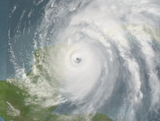
Image of Hurricane Wilma in October of 2005 which was generated using Aqua/MODIS, Terra/MODIS, and NOAA/GOES data. Credit: NASA/Goddard Space Flight Center Scientific Visualization Studio
Remote sensing is “not only changing how we do things, but it’s changing what we can do,” said Jack Harold, Chair of the National Research Council’s 29th Disasters Roundtable Workshop, which took place July 7, 2010 in Washington, DC. During the half-day workshop, members from government, industry, and academia discussed the scientific, technological, and political dimensions of how remote sensing technology can aid in disaster relief. The focus of the workshop was twofold: to construct a vision for the next ten years of how remote sensing data can be used pre- and post-disasters, and to leverage known technologies and processes and explore unrealized potential in this type of data.
The workshop envisioned 2020 remote sensing to include improved technologies such as small, low-cost, and low-mass sensors and increased use of “sensor webs,” networks of small, autonomous technologies that are distributed around potential disaster sites to provide early warning information and monitoring. There was also a call for more widespread use ofhyperspectral imaging. Hyperspectral imaging completes the picture of disaster relief, one attendee said, by allowing for chemical analysis in addition to image analysis.
Streamlining the movement of data from air and spacecraft to “boots on the ground” was another goal for 2020 vision. Workshop attendees discussed at great length the problem of moving data “the last mile”—from data producers to incident managers on the ground. The discussion focused on finding ways to get the right data to the right people quickly and with little need for interpretation. To address this, data producers need to communicate with data users in order to determine what users need and then use the existing tools to meet those needs. With the growing use of smart phones and GPS, community remote sensing (sometimes known as crowd-sourcing) processes for data collection and distribution will also become standardized.

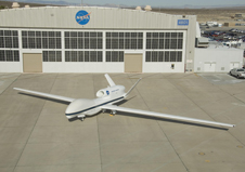
One of NASA’s two Global Hawk high-altitude unmanned science aircraft capable various kinds of atmospheric science. (Click image for close-up) Credit: NASA/Dryden Flight Research Center
Attendees identified a lack of well-defined roles and responsibilities and coordination among federal, state, and local governments and barriers to data sharing across federal and international agencies with disaster relief organizers as impediments to improved response times, as well as the future vision for remote sensing technology.
Solutions that participants offered include: engaging the disaster user community in workshops to determine their needs; rapid collection of pre- and post-disaster data; operational satellite and aerial programs for consistent disaster monitoring; increased use of commercial-off-the-shelf products; awareness campaigns for user communities; reductions in bureaucratic delays; and better information technology (IT) and software systems for turning data into usable information on the ground.
Organizations participating in the workshop included NASA, the United States Geological Survey (USGS), Department of Homeland Security (DHS), Federal Emergency Management Agency (FEMA), the National Oceanic and Atmospheric Association (NOAA), the Secure World Foundation, the World Bank, DigitalGlobe, and the Rochester Institute of Technology.
Listen to the audio of the workshop and view the keynote speaker’s presentation.
Find a summary of the findings from the International Space University’s Team Project at NASA Ames Research Center on the topic: G.Dyke, et al., Dream project: Application of earth observations to disaster risk management, Acta Astronautica (2010), doi: 10.1016/j.actaastro.2010.06.18


