


A NASA-led project called “The Internet of Animals” combines Earth satellite observations and animal tracking data to get a better idea of changing habitats.
The Internet of Animals, a collaborative research project with the U.S. Geological Survey along with several universities and institutions, is giving insight into the intersection of animal movement patterns and climate. By combining remote sensing data with wildlife tracking tags, experts can get a better idea of scientific needs to manage conservation at the federal level.
In this episode, you’ll learn about
- Advances in remote sensing and animal tracking technology
- How remote sensing data can inform decision makers on addressing climate challenges
- How animal movements can indicate changes in habitat
Related Resources
NASA’s Applied Remote Sensing Training Program
APPEL Courses
Leading Complex Projects (APPEL vLCP)
 Dr. Morgan Gilmour is a research scientist at the NASA’s Ames Research Center in California. Her research focuses on the intersection of remote sensing data from satellites and animal telemetry to understand marine ecology and conservation. She has a Ph.D. in Ocean Sciences from the University of California, Santa Cruz, a Master of Science in Biology from Bucknell University, and Bachelor of Science in Wildlife & Conservation Biology from the University of Rhode Island. She is the recipient of several awards and fellowships, including the 2022 United States Geological Survey’s STAR Award and the 2019 USA-to-Australia Postdoctoral Fellowship from the American Australian Association to do research on plastic pollution in marine environments.
Transcript
Andrés Almeida (Host): Large seabirds called frigate birds can stay aloft for weeks at a time, hardly ever flapping their wings. They take advantage of thermal currents and can soar to heights of 4,000 meters. That’s about two-and-a-half miles above the planet. These high-flying birds are giving scientists a better understanding of Earth’s dynamic Planetary Boundary Layer, or the PBL. That’s the atmospheric layer closest to the ground where we experience weather and feel air quality. So how are we getting Earth data from frigate birds anyway?
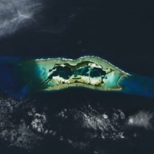
Enter the Internet of Animals, a NASA-led research project that combines remote sensing data, or Earth observations, with information transmitted from tagged marine wildlife. The project uses tracking data collected from animals at Palmyra Atoll, a small island between Hawai’i and American Samoa. So what have scientists uncovered so far?
Welcome to Small Steps, Giant Leaps, the NASA APPEL Knowledge Services podcast where we tap into experiences, lessons learned, and novel ideas from the agency’s technical workforce. I’m your host Andrés Almeida.
Our guest this episode is Dr. Morgan Gilmour of NASA’s Ames Research Center in Silicon Valley. A marine ecologist by training, she’s a research scientist participating in the Internet of Animals.
Hi, Morgan, thank you for being here today.
Gilmour: Thank you. Good to be here.
Host: How did you become involved with the Internet of Animals research project?
Gilmour: So, I’m a research scientist at Ames Research Center in California. And I have a background in ocean sciences. And I’ve done a lot of animal tracking over the years, mainly with birds called seabirds. And so, they mainly live in the ocean. They rely on the ocean for food like fish and squid. And I previously was working at USGS [United States Geological Services] also doing animal tracking, and the Internet of Animals project began a couple of years ago. And it was, it was just a really good situation of good timing. And I was able to transition from USGS to NASA to work on this new animal tracking project, but also bring some of the animal tracking work I’d done at USGS with me. So I continue to work on some of those data at NASA, which has been really awesome.
Host: What are some of the motivations behind the project? Behind the research?
Gilmour: So the Internet of Animals is a project where we combine we’re doing a lot of things. One main project I’m working on is to combine animal tracking data with remote sensing to answer questions about characterizing animals’ habitats. And so, this actually really builds on NASA’s specialties in all the satellites and satellite products that NASA generates, to really be able to use those data to really understand not only where animals are going, but also the habitats that those animals are actually living in, that we can’t necessarily deduce just by looking at animal tracking data alone.
And so the Internet of Animals has kind of built on that idea. Originally, about two years ago, the federal agencies that are mandated to protect wildlife and ecosystems. So the US Fish and Wildlife Service, USGS, NOAA…approached NASA with this idea of a feasibility study, like, what agencies are using animal tracking data to answer, you know, questions at the federal level? And what are the capabilities of building a new next generation animal tracking system? You know, that might include NASA? And so we are trying to answer those questions by interviewing people and animal tracking community, both at universities and at different agencies to understand why people are tracking animals, what kind of data they’re getting, what kind of data they might need.
And so this includes things like remote sensing, and like the different resolutions of remote sensing in different types of products. I work in the ocean a lot. And so we really are interested in chlorophyll and sea surface temperature and surface currents and that kind of thing. But then people that work on land, obviously are interested in vegetation variables as well. And so just understanding how the animal tracking community and federal agencies can collect those data, use those data, and ideally, if we could build a new tag or new center or a new sensor on a satellite system that could help us answer those questions. What are those fuel requirements? Like what’s a wish list of the animal tracking community to help move in more tracking forward?
Host: Part of that includes the research that you and your team did out Palmyra Atoll out in the Pacific Ocean. What trends has the data shown? And actually, how did you do the research itself? Sure.
Gilmour: Sure, so that was a project I was working on. This was a collaborative project with the Nature Conservancy USGS, NOAA and several universities and the team came together to deploy tracking tags on nine different species of animals that are based at Palmyra. And so those includes things like three different types of seabirds, two types of dolphins, manta rays, reef, sharks and tuna. And the idea is that these animals are using all different parts of the atoll that is in the middle of a marine protected area.
Palmyra is in the Central Pacific Ocean. It’s about 1,000 miles south of Hawai’i. And there, it’s one of the five units, six units is one unit of the Pacific Remote Islands Marine National Monument, which is one of the largest marine protected areas [MPAs] in the world. And so those are centered on national wildlife refuges scattered throughout the Central Pacific Ocean. And those MPAs were initially established just based on geography. But we wanted to take the next step and ask if the room protected areas actually protecting the species that are in it. And so by putting tracking tags on all these different species of animals, we can start to build a picture of – are those animals staying within the marine protected area? Are they going outside the marine protected area? And using remote sensing data, we can then characterize habitats and say, “Okay, we know this animal is going north, what is the habitat look like north of the atoll?”
And then a project that we’re working on, in addition to that is then feeding those those modeling models into climate change scenarios and understanding how those habitats might change in the future under different scenarios. And that would enable us to understand if the marine protected area will be effective, you know, 10 or 50 years from now. And so as you might expect, the animals we tagged were both stayed close to shore. And some of them were really wide ranging. We had a blue marlin that traveled 2,400 kilometers to the west upon to the east of Palmyra. And we had a manta ray ago, maybe about 1,500 kilometers to the west of Palmyra. And we had one tuna that went out 1,500 kilometers north of Palmyra, almost all the way to Hawaii. And so it was really cool. Our whole team has done a lot of animal tracking data and all these different species in the past, and everybody is still really excited to see how far these animals potentially are going.
And so obviously, the animals are going, they’re staying inside the protected area, and they’re going outside the marine protected area, because they don’t, they’re obviously not aware of the MPA boundaries. And so us being able to just quantify those movements is really important. And then we were characterizing habitat with species distribution models. And those habitat models were showing the habitat that the model thought was most suitable for the different species [that] occurred both inside and outside the marine protected area. And so, this, again, is just it’s really great that we’ve been able to quantify that.
Host: Regarding animal tracking, how does Earth satellite data come into play?
Guest: Yeah, so we know where the animals are going, like, we have these GPS tracks, and we have these satellite tracks that say, “Oh, the animal went north, or the animal went south, or the animal spent five days in this one region.” And so that’s all fine and good, but at the same time, we want to know why the animal did that. And so by pulling in Earth observations, remote sensing from different satellites satellite products, we could start to build like a three-dimensional picture of where the habitat where those animals are going. Like, “Oh, sea surface temperature and chlorophyll were really ideal for, you know, tuna on this one spot.” That’s probably why the tuna has spent five days there, for example. And so Earth observations are really helpful to be able to characterize those habitats.
And one other aspect of the Internet of Animals project that we’re also starting to work on, on a different project, which I’ll talk about in a minute, is the idea of using animals as sensors of the environment. So animals that have tracking tags are equipped, you know, with basic GPS, and maybe there’s a temperature sensor on there or pressure sensor for animals that dive underwater. But the tag technology has advanced so much in the last 15 years that we can include additional sensors on those tags. And so we can measure things like humidity and pressure and, you know, maybe even wind or something or salinity. And so we can put those sensors on the animal tracking tags, and then we can actually measure the environment where they were. And we can use those measurements potentially to validate satellite measurements and observations. That is also something that people are starting to do, is be able to characterize the habitat based on measurements taken by the animals themselves.
So one project that I have started working on since I’ve joined NASA is that one of the species we were tracking at Palmyra is called the great frigate bird. And so this bird is a large seabird. They have about a six-foot wingspan, and they have a really small body. And so they have a really low wind loading. And so this enables them to fly on air currents really easily. And it means that they don’t have to flap. And so they can travel hundreds of kilometers across the ocean searching for fish and squid without flapping and so this is really energetically efficient of them to do. And so we had collected data on frigate birds to look at tracking, look at their use of the marine protected area.
But frigate birds, when they travel on the air currents, they hop on the thermals. And so these thermals are just rising air masses. And so the birds circle in the thermals all the way up to sometimes 4,000 meters high, which is just so cool, and so crazy. And they’re doing this like all day, every day and at night. And so the birds are just flying up to, you know, the top of the cumulus clouds, and then they’re soaring, and then they glide out of it down to the sea surface. And so they’re just moving up and down every day.
Looking at these data — so the altitude was collected, in addition to location and temperature on these particular tracking tags — watching that cyclical pattern, we realized that the birds are tracking the planetary boundary layer. And the planetary boundary layer, really briefly, is just the lower, the lowest level of that atmosphere that kind of surrounds the earth. And it kind of keeps the heat in at night. And it keeps the air pollution and it moves up and down every day. And it’s really hard to pinpoint the exact height of that. And knowing the height of the PBL is important for weather forecasting and air pollution models. And so it’s hard to do that with satellites. But our atmospheric scientists do their best.
But another way that we could potentially track is to use birds to, you know, have that fine GPS location of when the bird actually hit the top of the cloud and then started coming back down again. And so potentially using the animals as sensors in the environment — it’s been really cool to try to use frigatebirds sensors of the planetary boundary layer.
Host: That’s fascinating. It’s not just NASA satellite data, correct?
Gilmour: Yeah, I’ve been working with on the larger Palmyra project, for example, have been using data from the European Space Agency and from NOAA. There’s a lot of satellites up there and they generate different products that are at different temporal, especially with temporal resolutions. And so some of those products may be mapped up a little bit better in the middle of the Central Pacific Ocean, compared to other some other satellites and satellite products that maybe have coarser measurements. And so we are using lots of different satellites to be able to characterize habitats in the best way that we can in matching up those spatial temporal parameters.
Host: So what challenges and surprises have you encountered in your research?
Gilmour: Honestly, one of the biggest surprises is being able to study the planetary boundary layer with frigate birds. Before I worked at NASA, I’d never even heard of the planetary boundary layer. So it’s just been really cool to kind of explore that space. And yeah, I guess just from a research perspective, that’s just been really surprising because “frigate bird” and “planetary boundary layer” and “atmospheric science” are not words I thought I would put in the same sentence. So it’s been really cool.
Working with wild animals is challenging is inherently challenging. And so there’s a lot of logistical challenges that every animal tracking scientist encounters. And so I work mainly with marine animals, especially with seabirds, often on remote islands in the middle of nowhere. And so just the logistical challenges of getting out there in the first place can be a lot. But sometimes you show up, you know, you make all these plans and you’ve got all your buckets packed, because a lot of the work I do is just like from, you have to take a small boat to a small island. And so like all your stuff is just in six-gallon buckets from Home Depot. And, you know, you just lug all this stuff onto the island. And then you get to where you need to be on the island where all the birds are, and you discover that none of the birds are nesting. And it’s really hard to put animal tracking tags out and try to get them back if birds aren’t nesting, because they’re just kind of like all over the place. But if they’re at their nests, then at least like you have a better chance of trying to recover that tag. And so I’ve definitely encountered that multiple times where the birds just aren’t nesting, but nobody else is on the island to be able to tell you that you know. And so it’s just logistical challenges of working remote areas with wild animals, it’s not going to go away anytime soon.
Host: So can other researchers freely access the data?
Gilmour: Yeah, so we actually just published the dataset that I’ve been talking about from Palmyra Atoll. And so that was published a couple of weeks ago, and that is open access, so anybody can go and download those data. And then all the remote sensing data that I’ve been using are publicly available, anybody can just go online to various resources and download those data as well. So that helps make our studies reproducible, which we really want to be able to do, because, again, going back to the frigate birds in the PBL, you know, we collected the frigatebird tracking data for one purpose. And it took me joining NASA and talking with my supervisor about, you know, these altitude data for him to, you know, recognize that that could be related to an atmospheric process I’d never heard of. And so it’s so important to have all those data out there so that somebody can come at it with a completely new perspective. And so we’ve definitely been striving to promote that as well.
Host: So what opportunities untapped areas do you think exist for future wildlife research and space?
Gilmour: Yeah, so going back to the Internet of Animals: I mean, we are really interested in trying to figure out what what does the next generation of animal tracking look like? And so a couple of ways that we’re doing that are working off of that wish list that, you know, the animal tracking community has put together, you know, what parameters would create an ideal tracking tag. And a lot of the technology related to that has to do with making it small, so we can track smaller and smaller animals and collecting data and being able to transmit it back to us scientists at a relatively fast rate, and also using, you know, a pretty fine spatial resolution.
And so technology has advanced so much for tracking tags in the last 15 years. I’ve been involved in animal tracking data for about that long. I started off tracking albatrosses. Now, albatrosses are big birds, and so they can carry a big tag. And the thing about birds is they have to be able to fly with whatever you put on them. And so, albatrosses were the first, you know, some of the first species that were tracked. And so I started out working with big tags and albatrosses and over the course of the last 15 years, tracking technology has advanced and tags have become smaller so that we can put tags on smaller and smaller species, which has been really exciting. Building off of, you know, just advances in tracking technology and being able to make small tags is really great. But the other half of that that we’re exploring is different ways to transmit the data.
Tags are made small because they are making smaller and smaller batteries. But also, it depends on whether the tag does like onboard processing of, you know, GPS location, or you know, the different ambient sensor data that it’s collecting. And so being able to store and either translate, or not translate, and transmit those data are considerations that we have to make when trying to think about the next generation of animal tracking tags.
And so one, two different ways that we’re thinking about that there’s a project with USGS right now that’s looking at developing a long range radio tag. And that would mean, there would be an animal tracking tag that would communicate both with ground-based long range radio networks and also with, you know, potentially like a constellation of CubeSats in the future.
And so that would kind of expand our ability to track certain species in certain areas. And so this USGS project is designed and tagged specifically for sea otters on the California coast. And so the long range radio tag would not rely on satellites or the satellite system that most tags rely on right now. And it would enable us to again, develop a small tag that doesn’t have a lot of onboard processing requirements, because the long-range radio part of that the receiver on that end would do most of like the triangulation work, I guess, you could say.
So some development of using radar sensors on satellites to also identify tags that kind of give off like a passive signal. And so by having a passive tag, again, you don’t require big battery to require a lot of onboard computing power. But you do have some data that you can transmit to the radar, and then that satellite does most of the work. And so this will enable tags to be small and to last a long time. And so those are some of the advances that we’re talking about within the Internet of Animals project at least.
Host: And as the project moves forward, as research continues, you’ll likely discover maybe there are more areas of opportunity.
Gilmour: Yeah, yeah, for sure. Yeah.
Host: I want to ask, What was your giant leap?
Gilmour: So my giant leap probably was the first field job I had. So I am a seabird field biologist by training out of college. And so right after college, the first real field position I had was as a biological volunteer for the Fish and Wildlife Service on a remote island that I’d previously never heard of before, I applied to the job called Tern Island, which is in an atoll called French Frigate Shoals, which is part of the Northwestern Hawaiian Islands. And the Northwestern Hawaiian islands are not necessarily very well known by the general public, but they extend starting 500 miles northwest of Kauai and go all the way up to Midway Atoll. Battle of Midway is a common U.S. history point that people learn about in high school. And so that’s part of that chain of islands as well.
But so anyway, it’s just this huge seabird colony with like hundreds of thousands of seabirds nesting on it. And I didn’t necessarily know I wanted to work with birds coming out of college, but then landing on that island and just being immersed in this seabird world and remote location just really was, it was just — it was incredible. And the people that were working out there, there were grad students. And there were people working for the Fish and Wildlife Service, and there were people working for NOAA out there doing Hawaiian monk seal research. And just being in the middle of that was just so amazing to me, and I really never looked back.
And that happened 19 years ago, and I’m still, I still talk about it. And I’m still very grateful for that opportunity because that introduced me to marine ecology and all this hands-on seabird work and I’ve continued to work with seabirds and frigatebirds, specifically, ever since. So it’s just it’s been really cool that 19 years later, I’m working at NASA, but I’m still working with frigate birds and I’m still able to do marine ecology. It’s just, it’s been really cool but like to say that it pretty much started on Tern Island.
Host: Lovely. And it sounds like a lot of sunscreen, too.
Gilmour: Oh, so much. [Laughter]
Host: Morgan, thank you so much for being here with us.
Gilmour: Yeah, thank you so much. This has been really cool to talk to you.
Host: That’s it for this episode of Small Steps, Giant Leaps. For a transcript of this show and more about Morgan, or the topics we discussed today, visit our resource page at appel.nasa.gov. And don’t forget to check out our other podcasts like Curious Universe and Houston, We Have a Podcast. Thanks for listening.