


NASA’s Air Traffic Management-eXploration Project aims to accommodate the growing demand of traditional and emerging aircraft that share the friendly skies.
Have you ever arrived at the airport only to find out your flight was delayed? It can be frustrating, but it often happens for reasons out of our control. Well, good news: Researchers working on NASA’s Air Traffic Management–eXploration Project are seeking to make flying better and safer for everyone. Together with the FAA, NASA is transforming how we manage air traffic across the National Airspace System.
In this episode, you’ll learn:
- How NASA works with the FAA to improve air travel
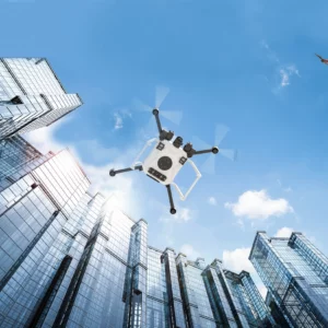
- How autonomous drones aid in emergency rescue operations
- How NASA is addressing the challenges of a crowded airspace

Credit: Sue Kaur
Supreet “Sue” Kaur serves as the systems engineering & integration lead for NASA’s Air Traffic Management-eXploration (ATM-X) project at Ames Research Center in Silicon Valley.
An expert in systems engineering, Sue specializes in the rapid design, integration, and validation of complex systems of systems (SoS). Her current work is centered on developing cutting-edge solutions that enhance the safety, efficiency, and interoperability of data-driven air traffic management systems. Through her leadership, she is helping shape the future of aerospace innovation and air traffic modernization.

Credit: Gita Hodell
Gita Hodell is a researcher at NASA Ames Research Center in California’s Silicon Valley. She has a rich background in aeronautics research from a Human Systems Integration perspective ranging from traditional air traffic management to new entrants and emerging technologies with uncrewed systems. Gita currently serves as the Public Operator Integration lead under the ATM-X Project’s UTM (Unmanned Aircraft System) Traffic Management.
Resources
Air Traffic Management-eXploration Project
UTM BVLOS Subproject
NASA Demonstrates New Wildland Fire Airspace Management System
NASA Kicks Off Testing for Remotely Piloted Cargo Flights
Courses
Foundations of Aerospace at NASA
International Project Management
Team Leadership
Transcript
Andres Almeida (Host): Have you ever arrived at the airport only to find out your flight was delayed? It can be frustrating, but it often happens for reasons out of our control. Well, good news: NASA and the Federal Aviation Administration, the FAA, are working to make aviation better for everyone. Let’s talk about it today on this episode of Small Steps, Giant Leaps, the podcast from NASA’s Academy of Program/Project & Engineering Leadership.
I’m your host Andres Almeida, and today, we’re exploring NASA’s Air Traffic Management-eXploration Project, or ATM-X. It’s an ambitious initiative aimed at transforming how we manage air traffic across the National Airspace. From integrating new types of aircraft to enabling digital air traffic systems, ATM-X is laying the groundwork for a safer, more adaptable, and more automated airspace. The project is even looking at improving and scaling up emergency rescue operations with the help of autonomous drones.
Supreet Kaur and Gita Hodell are here to talk about the goals of ATM-X and what the future of air travel could look like. Sue serves as the ATM-X systems engineering and integration lead at our Ames Research Center in Silicon Valley. Gita is the public operator integration lead under the ATM-X Project’s UTM (or Unmanned Aircraft System) Traffic Management.
Hi, Sue and Gita, thank you for joining us today.
Sue Kaur: Thank you for having us.
Gita Hodell: Thank you, it’s nice to be here.
Host: Sue, ATM-X is a broad project, but what is it exactly?
Kaur: ATM-X is air traffic management exploration. It’s a portfolio of technologies and solutions taking a holistic approach to advancing the future of aviation.
So, we are looking at everything from the ground to high altitude operations at 60,000 feet and above. And if I’m going in the order of altitude, our research portfolio looks at several elements of air traffic management. We’re starting off with, we’re looking at modernizing airport operations and systems, so making gate to arrival operations more efficient, reducing delays and overall getting people in and out of their seats as quickly and safely as possible.
We’re also supporting the operationalization of drones for public good, and my colleague Gita will talk more about that and how we’re partnering with the Federal Aviation Administration to ensure drone operations are routine, safe, and efficient.
Additionally, we’re looking at the scalability of new aircrafts and capabilities like remotely-piloted operations, and we’re researching how would these aircrafts handle unexpected situations, such as lost communication, responding to sudden bad weather ahead, maintaining a safe distance from other aircrafts in the air.
And last but not least, we’re looking at everything 60,000 feet and above, categorized as Upper Class E. We’re essentially catalyzing higher airspace operations. So, that research is looking at what’s needed for crewed and uncrewed aircrafts to function effectively at those heights. This includes high altitude balloons, airships, supersonic planes.
So, I know this seems like a lot, but propelling us into the future won’t rely on a single innovation developed in a bubble – pun fully intended. In reality, all of this has to interconnect and work together. It’s the synergy, the convergence of multiple technologies coming together that takes us into the future.
Host: Sue (again) a lot of our listeners travel by air. How does this work directly impact them, and what goes on behind the scenes with air traffic management operations from pre-departure all the way to arrival?
Kaur: So, to answer this question, I need to take you through a journey. Let’s say you, Andres. You’re taking a flight from San Francisco Airport in California to LaGuardia, New York. What are you doing before you’re buckled into your seat, ready for takeoff?
Host: I’m probably looking at my phone.
[Laughter]
I shouldn’t!
Kaur: I mean, typically a person arrives at the airport, they check in, they go through security, they board the plane, and so forth. Meanwhile, there is a symphony of operations happening behind the scenes to prepare for your flight. Your aircraft is parked at the gate. It’s getting cleaned and refueled. Meals and luggage are getting loaded into the craft. Ground crew is performing technical inspections. They’re looking at the brakes, the tires, the other critical components. The pilots are performing their preflight checks while communicating with the air traffic controller, which is managed by the FAA. So, when you scale that to about 45,000 flights across the United States every day, that’s a lot of logistics and coordination. So, optimizing these ground operations is one of the research areas ATM-X is looking into.
So, we’re asking research questions like, “Are there elements which could be automated to streamline these processes? Can we digitize the communication and the information exchange between the pilot, the aircraft, and the air traffic controller?”
These are some of the tests that we’re conducting out of Moffett Field at NASA Ames Research Center. Today, we’re using our labs, our simulation facilities and our runways to take this research from experimental to operational.
Now, back to your journey. You’ve boarded your plane, you’re all buckled in, your phone is on airplane mode.
Host: It should be, yes.
Kaur: Ideally! [Laughter]
The plane is ready to leave the gate and push back. Assuming you have a window seat, what do you see when you look out?
Host: Well, I see the runway, the operations going around, probably the Air Traffic Control tower.
Kaur: Yeah, and you’re also seeing all these flights arriving, departing. You have trucks carrying cargo. You have ground crew walking around.
The airport is a very busy and dynamic environment, so while the aircraft is pushing back, the pilots have to be vigilant. They’re maintaining a safe speed and distance from other aircrafts, as well as the vehicles on the ground. They’re also monitoring the aircraft systems, still communicating back and forth with the air traffic controller to get their assigned runway. They’re reviewing their routes. They’re looking at the weather conditions ahead and so forth. Once they’re at the top of the runway, ATC gives the pilots clearance, they take off, and they climb until they’re at cruising altitude, and that’s when you can unbuckle your seat belt and stretch your legs. Now, when you put all of this together, we have one of the most complex air traffic control systems in the world, and aviation is a big part of our economy, whether that’s transporting people or cargo.
Now, given how dense airspace operations are today and the growing demand for air transportation in the future, another research question we’re trying to answer is, what will it take to integrate new aircrafts and technologies into the current US airspace? I’m talking about remotely piloted or autonomous planes, delivery drones, EVTOLs (aka flying taxis) and so forth.
So, the key word here becomes interoperability. These different aircraft systems, tools and people, they all need to communicate with one another and work in synergy, which is why ATM-X works with a number of industry partners around the country, as well as the FAA, we want to identify and solve the unique technical challenges that need to be overcome to graduate these research concepts to operational consumer technology, while ensuring we keep safety, scalability and efficiency at the forefront.
Host: It is quite a maybe it sounds cliche to say, but like a total orchestra, like a symphony, right? So much going on.
Kaur: Yeah.
Host: And I will get to you, Gita. But one more follow-up for you, Sue, is in a recent episode, we briefly discussed how NASA works with the FAA and private industry. What more can you tell us about how these partnerships benefit the public?
Kaur: Partnerships are key in driving innovation, because change does not happen in a silo or a bubble. It’s a community effort.
All stakeholders, and that includes NASA, the airlines, the pilots, the air traffic controllers, aircraft manufacturers, standard bodies and so on. The list is very long. We all need to work together and assess the impacts of these technologies we’re developing, because at the end of the day, we all have to operate in and share the same airspace. In this regard, I see NASA as a facilitator. We make connections, create new opportunities, and build relationships that just wouldn’t exist otherwise. We’re bringing all of these entities and their perspectives as well as their challenges to the table and get them talking with one another.
Another role NASA plays in partnerships is a technology validator. Our industry partners, ranging from startups and small businesses to large corporations and global enterprises, they turn to NASA for guidance and support when they’re developing their solutions, they’re relying on our expertise and our test facilities to ensure their innovations meet safety standards, perform reliably, and can integrate seamlessly into real world applications. That way, they can bring their products to the market with a degree of confidence.
Another role we play is accelerating commercial growth. Now, most people know that NASA has a legacy of innovations which benefit humanity. All of our research and development ultimately is for the public good. That’s what drives our science and engineering. What people may not realize is that as a government agency, we don’t profit from our innovations. We share our findings with the public for free. Literally anyone can go online and access our reports, data sets, software tools. And a lot of people do.
These innovations get picked up by people in industries ranging from telecommunications to health care to agriculture and then spun off into real world benefits that are a part of our everyday lives. In that sense, NASA provides a significant return on investment for our taxpayers.
So, in summary, through partnerships, NASA’s fueling industries were delivering lasting benefits and trying to enhance the quality of life for people everywhere.
Host: Gita, I want to turn to you. NASA has been working closely with the FAA at it’s called the Key Site in North Texas. Can you walk us through what kind of technologies we’re testing and validating?
Hodell: Yeah, absolutely. So, you know, normally when we think of NASA, we think of like flight testing or demonstrating new technologies. And the thing that’s so interesting about the Key Site in North Texas is that it’s a true operational implementation of UTM, for the first time in the United States. So, it’s no more flight testing. It’s just made the leap from the research world into the real world, which is really cool to watch unfold.
And NASA actually developed the UTM concept over the last decade, and we’ve already conducted a whole bunch of flight tests and demonstrations with our partners. So, our key stakeholders are the industry, the FAA and public safety. And then around 2023 it was like, “Okay, no more flight tests. Let’s actually do this, and let’s start using UTM in the real world.”
So, it might be helpful if I talk a little bit about what UTM is.
UTM stands for UAS traffic management, or drone traffic management, and it is a traffic management concept that was created by NASA. It’s an ecosystem of traffic management services that are meant for small drones, like 55 pounds and below, and they’re flying 400 feet and below. And so, by using these services, we can enable safe and scalable drone operations.
So, like, by contrast, in traditional aviation, the FAA is this centralized provider of air navigation services. So, these are your air traffic controllers and tower controllers and command center people. But that type of thing doesn’t exist for small drones in the low altitude. And so ,the concept is that automated services will fill in these air traffic services instead of air traffic controllers to fill in this gap.
Today, there’s a lot of software companies out there that have created automated services to be used. There’s lots of different ones, like you can do terrain and weather avoidance, or you can strategically organize the airspace to avoid collisions and things like that.
And so, in order to deploy these services to be used by real drone operators, the FAA has developed the near-term approvals process, and this process ensures that all of the automated services that are being used for drone traffic management are meeting all the same standards and requirements. And by the way, NASA is also going through the near-term approvals process alongside industry, because we create services and we’re also drone operators, it’s just we’re on the government side instead of the commercial side. And so, in a nutshell, you take the UTM airspace management services plus the drone operators that are using the services, and that’s how you get UTM for beyond visual line of sight operations.
Host: Do you say it [BVLOS], “biv-loss,” correct?
Hodell: Yeah, it’s, we don’t know how to pronounce it. [Laughter] “bee-vee loss,” “biv-loss,” “B-V-L-O-S…”
Host: [Laughter] Yeah. Can you in that sense, then, can you explain a little bit about BV or BVLOS? We’ll say, I’ll say, “biv-loss.” You can say however you like it. And give us an overview of just what it is and what are the challenges with BVLOS.
Hodell: Yeah, definitely, so, first of all, to operate a drone today, the vast majority of people are flying under the FAA rule Part 107 which basically just means that you are required to see your aircraft at all times with no visual enhancements while you’re flying it.
But BVLOS stands for Beyond Visual Line of Sight and it specifically refers to this condition where you have a drone operator that’s standing on the ground, and they’re flying the drone beyond their ability to visually see it. And in order to do that, you need explicit permission from the FAA. So, these are not typically your hobbyist drone pilots who they just want to, like, throw something up in the air and take some nice pictures.
These are going to be your professional drone operators, so folks that are doing commercial package delivery services or public safety. And what they’re doing is using additional technologies like cameras or GPS tracking or sensors that are sort of installed at different places around the city to help them navigate and observe their environment while they’re flying. And this is really the new frontier for drone operations. If we can get that right, then we’re going to see drones scale up quite a bit.
Host: I imagine you’re seeing a little I imagine you’re seeing a little bit of scalability right now…
Hodell: Yeah.
Host: …which must be a big challenge, yeah?
Hodell: Yeah. The biggest challenge, in my opinion, would be to get approvals to fly BVLOS from the FAA. It’s a pretty high bar that you have to demonstrate that you have a sufficient amount of supportive technology to fly in a safe way.
And to add to that difficulty, they’re all approved on a case-by-case basis. So, for example, if you’re someone that’s flying over a large corn field, you’re not going to have the same amount of risk associated with your operations as someone who is flying like over a densely populated urban area or flying near an airport or over some critical infrastructure. There’s a different risk tolerance for each type of operation that’s out there. And so, because there are so many differences, there’s no definitive checklist that you can go to where the FAA can say, “All right, if you have A, B, and C, then you meet the requirements and you’re safe to fly BVLOS.” It just doesn’t work like that.
So, this brings us back to what is going on at the Key Site, because what’s going on in practice is that the industry is using UTM services, specifically the strategic deconfliction service, to prove to the FAA that they can fly BVLOS operations all day, every day, in a safe way. And strategic deconfliction, essentially, is automation that makes sure that before anyone takes off, there are no overlaps.
So, you kind of file your flight plan, what’s known as your operational intent. It checks everyone else’s that are around you, and it checks for conflicts or overlaps. And if it detects one, it’s going to send you a notification. And in addition to that, you’re not going to be allowed to take off if there is any kind of conflict detected. And so, that is what is meant by strategic deconfliction. Essentially, it’s on the ground. It’s before you fly. All of these conflicts are predicted and they’re resolved, ideally, before you even take off. It’s so much more difficult to deal with conflicts after you take off and you’re already flying. And so, that is the core technology that’s being leveraged so companies and public safety can get BVLOS approvals at the Key Site in.
Host: And “public safety” you’re referring to, also emergency operations, right, like 9-1-1 calls, potentially?
Hodell: Yeah, absolutely. So today, drones are being used all across the U.S., in some cities to respond to 9-1-1 calls, they can deliver critical medical supplies when, for example, someone’s going into cardiac arrest, or maybe there’s a drug overdose, or they really need an EpiPen. They can also be used to inspect fire lines and wildfires, or to do search and rescue over land and water. And so, the list of applications is enormous for public safety, and that was one thing that was immediately apparent, like 10-15, years ago, is that drones are able to help public safety respond faster and use more accurate and real-time information to help save lives.
Host: How has NASA enabled public safety at the Key Site or in the Key Site?
Hodell: You know, public safety has been using drones for a long time. They’re absolute power users of drones, and so any company that is looking to do drone delivery services in a community, they really need to make sure that they’re not interfering with emergency first responder missions.
And in the early days of the Key Site, it was originally only commercial delivery companies who were participating. And by the time NASA got involved, we reached out to [the] local North Texas public safety community, and we made sure that they were aware of what was going on, and also, we got some of them to participate in the key site. So that’s been NASA’s contribution to the whole thing. And it’s incredibly important that as the UTM ecosystem evolves, both commercial and public safety groups are included because they operate in very different ways, and each of their unique needs has to be met in order for this thing to work.
So, if you just think of it this way, like when you’re having a really bad day, and you need to make that 9-1-1 call (unfortunately, it happens), you really, really want a first responder to arrive on scene within minutes, right? And that’s what drones can do today. They’re called Drone as First Responder programs, and they can get to your call so much faster.
But then, let’s say your neighbor also orders a pizza delivery that’s going to be delivered by drone. And that means you’re going to have two drones arriving to the same location at the same time. And what you really don’t want is for that pizza delivery drone to block the emergency first responder drone or slow it down in any way. And so, when we talk about air traffic management and how we organize the airspace, that’s exactly what we’re talking about.
Like, there needs to be a prioritization structure that’s baked into the software that says, if you are responding to an emergency call, you have priority over the airspace, over someone else who has a lower priority.
And it’s the same thing as the rules of the road today, like, if you’re driving down the road and you see sirens on, you get out of the way. So, it should be the same thing in the air.
Host: For emergency drones, what use case is there right now? Because, say I have an emergency, I’m on the side of the road or in my house. How does it work?
Hodell: I mean, it depends on what the problem is. What is likely to happen is that a drone will be deployed immediately as the 9-1-1 call comes in, and it’s going to use cameras to observe what’s going on in the situation. So, it’s going to identify, do you need supplies delivered to you? What is the situation? Who are the people that are at risk? How many are there? Where are they? And this information can be fed back instantaneously to the ground-based services.
Host: What are some recent highlights or milestones from the ATM-X and UTM BVLOS projects. Or “bee-vee loss?” I’m gonna change it up this time.
[Laughter]
Hodell: I think the history of milestones by ATM-X is really influential on where we are today in UTM and also where we’re going next in aeronautics. It goes back to commercial aircraft research that NASA did with trajectory-based operations.
So, meaning, rather than collecting data on where your aircraft is in this point in time, you move towards a model where your planned trajectory is taken into account. And that’s what air traffic control can use to deconflict and make the airspace more efficient and clean. And this is the same model that we use with UTM, although planned trajectory is called operational intent, everyone submits their operational intent, and this is what the automation uses to deconflict.
And this concept has really brought applications, not only to small drones for UTM, but also to passenger carrying drones for urban air mobility and large cargo drones and high-altitude weather balloons and supersonics, and even all the way up to, like, space. So, this just helps us create a more info centric airspace that is proactively de conflicting, rather than reactively.
Host: Sue, what’s coming up that our listeners can look out for?
Kaur: Well, Andres, we have a pretty busy year ahead. We have multiple major simulations and flight tests coming up, and with our commercial partners, we’ll be diving deeper into several research areas. So, we’re looking at improving operational efficiency at major airports, so reducing delays and the implied costs that come with those delays. Small UAS operations and use cases, so using drones for package or medical delivery and emergency response. We’re also looking at autonomous aircraft operations with our partners out of California and Texas.
So, we’re studying how can we enable digital information exchange and detect and avoid technology using sensors and machine learning algorithms.
We’re also looking at cooperative operations – the etiquette, if you will – for new entrants in air spaces below 400 feet, for drone use cases, as well as Upper Class E 60,000 feet and above for use cases around telecommunication and perhaps environmental monitoring, for emergency wildfire response.
We’re also launching a quarterly newsletter to share the outcomes of these simulations and tests with the public. But in the meanwhile, listeners can go to the ATM-X website on nasa.gov and learn more about our technology portfolio and ATM-X objectives and goals.
Host: We’ll link the ATM-X page and the NASA Aeronautics page on the podcast website there so listeners can take a look and keep up with the latest updates on ATM-X, which also complements our recent episode, right, on Air Mobility Pathfinders.
Kaur: Yes.
Host: I’m sure there’s some collaboration, some, integration?, there a little bit with what you all do.
Kaur: Yes. So, AMP is I would describe as our sister project. The way I see all of the projects and different research areas across the Aeronautics Research Mission Directorate is: We have one big problem, and these projects are answering a different facet of that problem. But at the end of the day, everything we develop is meant to work in synergy. We complement each other’s research and innovations.
Host: That’s the word, complement. My final question for you both is, and Gita, I’ll start with you: What was your giant leap?
Hodell: My giant leap, it was working with public safety for the first time ever.
I’ve been just in aeronautics for almost 10 years now, and I’ve never come across the chance to work with public safety. I am totally the type of person that I want to understand all walks of life, no matter how different from me. And I don’t think anything could be further from my humble little desk job than, like, an emergency first responder who gets up every day and risks their life to save lives, and it’s just been very eye opening and exciting to work with that community of people and understand what are their needs and their challenges,
Host: Excellent. And Sue, what about you? What was your giant leap?
Kaur: Over the last 10 years, I’ve been studying, researching and implementing systems engineering across different activities and projects.
And when you’re working on a sole project, you kind of have your blinders on and you’re just diving into that technology, but now, as the lead systems engineer for ATM-X, I’m providing guidance on this dynamic portfolio of systems and technologies, and as I’ve described, we’re covering a very wide range in depth.
So, the challenge now is integrating everything, getting everything to work in harmony, the interoperability. So, my role has gone from having my boots on the ground to advising our systems engineers and our technical authorities on how we can tailor and adapt systems engineering practices, perhaps developing new processes that are more efficient. But most importantly, I think the biggest leap is going from being this technical person behind a screen to a more public facing advisor. As leaders, we live to serve. We don’t just provide guidance, but we also live to serve the needs of our teams and the public at large. And that’s been the biggest transition, the biggest leap, if you will, in my career so far.
Host: Wonderful. Sue and Gita, thank you so much for joining us. This is really interesting and can’t wait to see where all this goes.
Kaur: Thank you for having us. This has been great.
Hodell: Thank you so much.
Host: That wraps up another episode of Small Steps, Giant Leaps. For more on Sue and Gita and the topics we discussed today, visit appel.nasa.gov. That’s A-P-P-E-L dot NASA dot gov. And while you’re there, check out our other podcasts like Houston, We Have a Podcast, Curious Universe, and Universo curioso de la NASA. And remember, next time you take a flight, that’s thanks to NASA research. Safe travels and thanks for listening.
Outro: Three. Two. One. This is an official NASA podcast.