

![]()
By Donald Pettit
Cities at night, when viewed from orbit, offer a spectacular display. 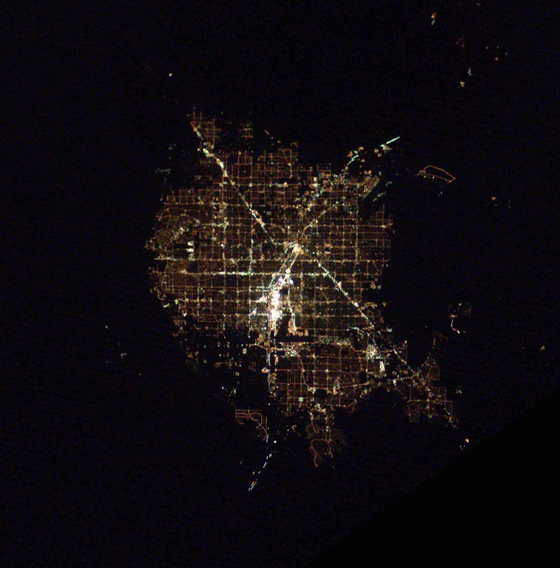
Although this light is a form of pollution that masks our earthly views of starry nights, from orbit it is an amazing display that radiates something about who we are into space. As crewmembers on the International Space Station, we now have the opportunity to observe and study these patterns of light and record what they have to tell us in ways that satellites currently cannot. The patterns that surface when viewed from orbit show the intersection among geography, technology, and culture and are worthy of recording for scientific study as well as for their beauty. Perhaps what we learn can even help us minimize these displays and once again give us back our starry nights.
From orbit, the unaided eye sees incredible detail when looking at cities at night. But capturing clear images of cities at night on film has eluded the best efforts of astronauts for years. Details on Earth scoot by at an amazing speed of 4.4 miles per second due to orbital motion. Getting a daytime picture is hard enough. And to obtain truly sharp images, even during the daytime, the camera must be panned to cancel out orbital motion while using the fastest possible shutter speed. During an exposure of 1/1000th of a second, 7 meters of Earth motion occurs; the resulting image will be less than optimum without this compensating motion.

Typical western U.S. cities, Las Vegas (top) and Los Angeles (bottom), are defined by yellow-orange sodium vapor-lit streets in grids. Airport runways stand out as dark lines where, surprisingly, it is better to land an airplane on a dark runway than a well-lit one. At the edge of town, the lights abruptly fade into the surrounding desert. The “Strip” in Las Vegas is probably the brightest spot on Earth.
Obtaining good images of cities at night requires exposures as long as one or two seconds, which, with uncompensated orbital motion, would show city lights as streaks. Obtaining reasonable images requires one to float over the window and slowly pan the camera while looking through the viewfinder to cancel out orbital motion, while to the best of ones ability, holding the camera still in all other axes. Any jitters during this process result in a blurry image. Not surprisingly, images of cities at night have been disappointing to those who have taken them since they know that they are only a blurry approximation of what is actually seen.
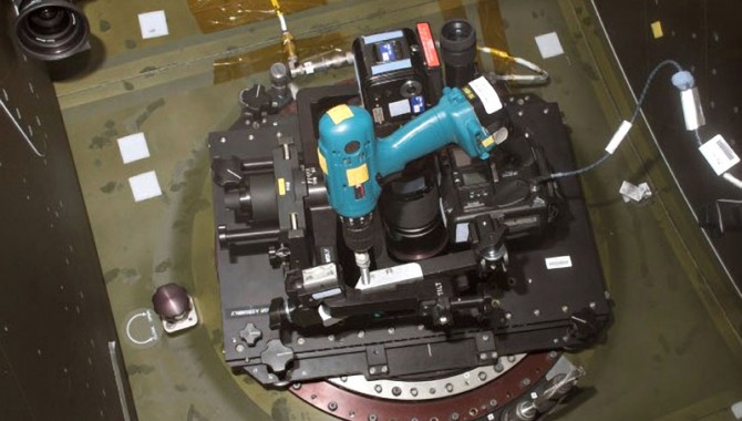
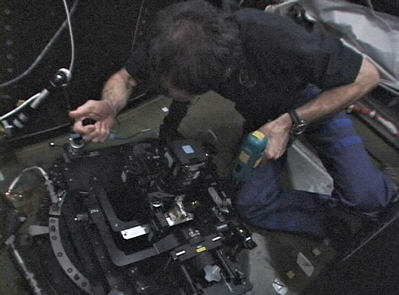
Living in a space laboratory for six months, you have the time to think about such problems and look for solutions. So during my off-duty time, I built an orbital tracking system from spare parts found in various nooks on the space station. In one stowage area, I found the old and now unused IMAX camera mount (used to film the IMAX movie Space Station) and used it as a framework for my tracking system. We no longer had either film or an IMAX camera on station, so no one minded my pressing this mount into a different kind of service.
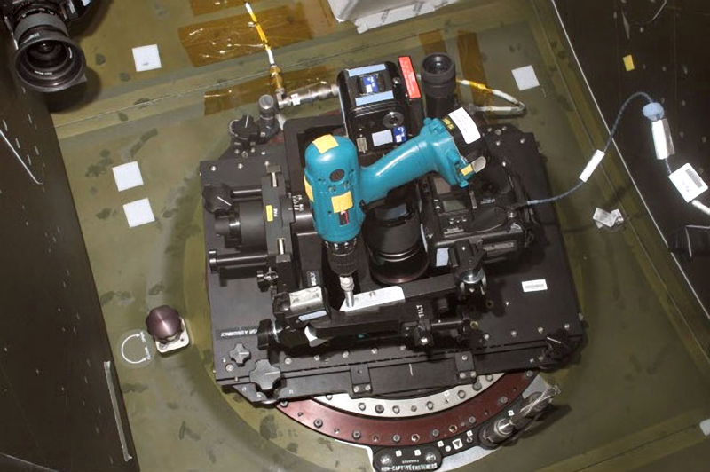
The improvised tracker placed on the US LAB module window.
The mount’s precision gimbal motions could be used to eliminate the effects of orbital motion only if a precise and smooth method of panning could be improvised. I mounted a long, threaded bolt on the IMAX platform so that it pushed against a plate and smoothly moved the platform in one direction when it was rotated. This direction of motion was then aligned with that of orbital motion so the mount would pan and cancel out the effects of orbital motion, at least long enough for a few exposures. A variable-speed drill driver was used to rotate the bolt; the rotation speed, and hence pan rate, could be varied by how far the drill drives trigger was pulled. I then attached two cameras to the mount, one with a long telephoto lens to act as a spotting scope and one with a medium-focal-length lens to take the photograph. Orbital motion was canceled by first looking through the spotting-scope camera and varying the rate of bolt rotation by squeezing the trigger until the image of the city below stood stationary on the cameras focusing screen. Then I took an image with the second camera using a cable release.
Donald Pettit using one camera to track city lights and taking the image with a second camera via a cable release. Amateur astronomers will recognize that what was improvised out of spare parts on the space station is no more than what they have been doing for decades with a simple tracking system dubbed a “barn door” that consists of two boards, a piano hinge, and a manually rotated bolt. The difference between handheld images of cities at night and those made with the tracking system is striking.
We are in the process of merging these astronaut-taken images of cities at night with the popular nighttime Earth images from the Defense Meteorological Satellite Program (DMSP). The DMSP images have near-world coverage but at a much lower resolution (about 3 kilometers in black and white) than the astronaut images now coming from the space station. A joint NOAA–NASA satellite under development will be optimized to take full-color, high-resolution images of nighttime Earth and eventually render this initial astronaut effort obsolete. Such is often the course with exploring a frontier. The special eye of humans pioneers the initial phase of discovery followed by the development of highly specialized machines that result in a more complete and better set of collected data.
The richness of how humanity sprinkles lights across the nightscape is striking from orbit. Colored patterns, caught in a triangle between technology, geography, and culture, radiate into space something about who we are. If the lights are mercury vapor, the cities will appear blue-green, while sodium vapor will yield yellow-orange. Some cities are dark with bright main arteries while others illuminate the whole urban area to an extent that matches the “yellow zone printed on an atlas. After living in space for a while, one can quickly tell what part of the world one is over simply from the patterns of city lights. While considered a form of light pollution and a display that can and should be minimized, their orbital appearance is spectacular. Cities at night may very well be one of the most beautiful unintentional consequences of civilization.

Above: Two images of Montreal, Canada, taken from the International Space Station. The best handheld image is shown on the left, and on the right is an image taken with the improvised barn-door tracker. Once this technique of operating the barn-door tracker was refined, astronauts used it to take images all over Earth. The resolution of ground objects in these new images is about 60 meters, and the current database of cities at night is now at about eight thousand, gathered by many crews.
 and Tel Aviv with Jerusalem in Israel (right). A grid of northsouth, eastwest streets typifies U.S. cities, whereas Europe and the Middle East<br /><br /><br /><br /><br /><br /><br /><br /> show a tangled pattern of lighting.")
Above: Chicago (left) and Tel Aviv with Jerusalem in Israel (right). A grid of north–south, east–west streets typifies U.S. cities, whereas Europe and the Middle East show a tangled pattern of lighting.
 shows blue-green (mercury-vapor lighting) in the older original town center and yellow-orange (sodium vapor) in its newly<br /><br /><br /><br /><br /><br /><br /><br /> growing borders. Tokyo (right) typifies the<br /><br /><br /><br /><br /><br /><br /><br /> blue-green lighting of Japan's major cities.")
Above: So Paulo, Brazil (left), a major urban area, shows blue-green (mercury-vapor lighting) in the older original town center and yellow-orange (sodium vapor) in its newly growing borders. Tokyo (right) typifies the blue-green lighting of Japan’s major cities. The dark spot in the center of town is the Emperor’s Palace; Narita Airport terminal is the bright spot to the east.
 with Brussels at the bottom, and Milan Italy (right). Spider-web networks of streets typify the older European cities")
Above: Antwerp, Belgium (left), with Brussels at the bottom edge, and Milan, Italy (right). Spider-web networks of streets typify the
older European cities.
 bordering Juarez, Mexico. The square of the District of Columbia (right) is clearly defined with an eastwest dark line identifying the National Mall.")
Above: El Paso, Texas (left), bordering Juarez, Mexico. El Paso appears with a grid of illuminated streets with relatively dark areas in between. Juarez displays scattered light in an area defining the city limits, matching the urban area “yellow zone” printed on an atlas. The square of the District of Columbia (right) is clearly defined with an east–west dark line identifying the National Mall with the Capitol seen as a bright spot on the east end and the Lincoln Memorial on the west. Center is the Washington Monument, and the Jefferson Memorial is seen as a spot of light on the south side of the bay.

Above: A mosaic from the southern tip of South Korea (upper left) to the northern Kyushu coast of Japan (lower right). Fishing boats using bright Xenon lights are in the sea between South Korea and Japan with some lights blurred by sea fog. Bright Xenon lights are used at nighttime to lure squid into nets.
Many of these images are currently available on the Web for download, including a movie and a NASA educational poster of cities at night. The following links are good places to find more information:
- Cities at Night: The View from Space
- Los Angeles at Night
- Cities at Night: An Astronaut’s View
- Cities at Night: an orbital tour around the world
- Cities at Night Poster (Front)
- Cities at Night Poster (Back)
About the Author
 |
Donald Pettit has logged more than 176 days in space and over 13 extravehicular activity hours. He lived aboard the International Space Station for five and a half months in 20022003 and, in 2008, was a member of the STS-126 crew. |