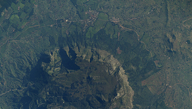
This image from SERVIR’s ISERV depicts a tea-growing region in southern Malawi. Tea growers benefit from the frost-potential maps provided by SERVIR, which help them minimize damage to their crops.
Photo Credit: NASA
A unique partnership between government agencies leverages space-based data to make a critical difference in the day-to-day lives of people on Earth.
When a major disaster strikes any region of the world, governments around the globe take action to help address the problem. But what happens when more localized catastrophes, such as floods or forest fires, occur? The event might not make the international nightly news, but it can be devastating for the country involved. That’s why NASA and the U.S. Agency for International Development (USAID) created SERVIR: a program that employs the extraordinary work done on the International Space Station (ISS) to help people in developing nations on Earth overcome profound local challenges.
“It is, in my estimation, one of the most powerful, awesome tools that our two organizations are able to give to humanity,” said NASA Administrator Charles Bolden.
SERVIR uses an ISS-based imaging system called ISERV: a camera and telescope system that collects approximately 1,000 images each day as the space station travels over 90% of Earth’s populated areas. From floods and volcanic eruptions to deforestation, ISERV captures images so people can use that data to address problems before consequences become deadly.
“The SERVIR Program,” said Eric Postel, USAID Associate Administrator, “works in collaboration with organizations around the world to help developing countries make use of the information coming from these Earth-observing satellites.” He added, “I don’t think our imaginations have even fully tapped all the possibilities that we have in working with NASA…in terms of turning this data into things that will make a difference to the day-to-day lives of people in incredibly remote villages or extremely poor people.”
The program supports hubs in Central America, eastern and southern Africa, the Himalayan region, and—as of a few weeks ago—Asia’s lower Mekong region by providing satellite-based Earth monitoring, imaging and mapping data, and geospatial information. The goal is to help people in these areas address significant local challenges through access to information that enables them to make crucial decisions in a timely manner.
The material available through SERVIR can make a profound difference. In Bangladesh, monsoon season floods can devastate the country, yet getting adequate advance warning would require keeping watch on river flow hundreds of miles beyond the nation’s borders. With SERVIR, they can get that information from satellite data.
The change has been remarkable. “What we’ve seen in the last monsoon season was a flood that typically would have taken a couple thousand lives took seventeen,” said Jennifer Frankel-Reed, Senior Climate Change Specialist at USAID.
SERVIR was conceived by two individuals: one from NASA, Dan Irwin, and one from USAID, Carrie Stokes. “What makes SERVIR really exciting is it’s demand driven,” said Irwin, Director of the NASA SERVIR Coordination Office. “What we try to do is listen, understand what the cares and concerns are of the countries, and then try to bring to bear and make that match of do we have tools, do we have assets that can really help with that issue that that country has.”
“The ultimate objective with all of this is to really turn data into decisions,” said Stokes, USAID Geospatial Information Technology Advisor. “And this partnership that we have had with NASA and continue to grow into the future is helping us do that.”
Astronaut Samantha Cristoforetti stressed the importance of taking care of people on Earth and the unique role that the ISS can play in doing so. “When you’re up there on the space station, you’re up there as a crew, an international crew… It’s the six of you, and you have to take care of each other… Otherwise things will go wrong, very wrong. Then you look out the window and you see Earth. It’s so obvious, when you’re looking from outside, that Earth is nothing else than a spaceship just like our International Space Station—just a lot bigger, and it’s been there for a long time, but it’s really a spaceship that takes us on this journey through space. The billions of human beings who are on the planet…we’re really the crew of this spaceship. So just like on the space station, we have to take care of each other.”
Through SERVIR, NASA and USAID are leveraging science and technology to do exactly that.
“We like to say about station that we’re working off the planet for the planet. And I think that that equally applies to SERVIR,” said Bolden. “Together, we’re contributing to the effort to help bring our space-based science down to Earth for real-time and real-world applications that are changing the lives of people where they live.”
Watch a video about the applications of the SERVIR Program.


