

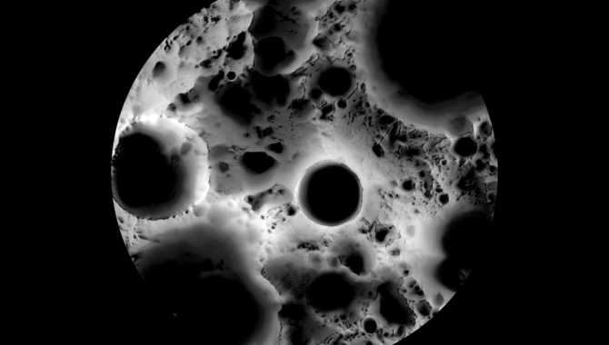
In this multi-temporal illumination map of the lunar South Pole, Shackleton crater is in the center, surrounded by larger craters and rugged terrain. The map was created with images from NASA's Lunar Reconnaissance Orbiter.
Graphic Credit: NASA/GSFC/Arizona State University
First landing marks the start of concentrated exploration.
It’s 13 miles across Shackleton crater, a bowl-shaped depression at the Moon’s South Pole. The rotational axis of the Moon is actually within the crater, near a portion of the raised rim, which has been well-preserved in the 3.6 billion years since it was formed by an object violently colliding with the lunar surface. The rim, which is constantly lit by the Sun, is in stark contrast to the crater floor, an estimated 2.6 miles below, which has likely been in constant darkness for billions of years.
Craters near Shackleton are even larger. Nearby Shoemaker crater is 31.6 miles in diameter and 1.5 miles deep. Amundsen crater is 64 miles in diameter, with low sloped walls that might facilitate future exploration. The Faustini crater is 24 miles in diameter. The floors of these craters are part of a vast area at the Moon’s South Pole—more than 10,000 square miles—in permanent shadow. Temperatures on these crater floors could drop below -330°F.
“You look at pictures of the South Pole, it’s not like what you saw where Neil [A. Armstrong] and [Edwin] Buzz [Aldrin] were landing, constantly lit from the sun. A few craters here and there. The South Pole of the moon is pockmarked with deep craters and because of the angle of the sun coming in, most of those craters are in total darkness the entire time,” said NASA Administrator Bill Nelson, speaking at a recent NASA press conference. “It lessens the amount of area that you can actually land on and utilize.”
In late August, India’s space program—a signatory of the Artemis Accords—became the fourth nation to perform a controlled landing on the Moon, and the first to land near the South Pole. The Chandrayaan-3 spacecraft includes a propulsion unit that powered the flight to the Moon, the Vikram lander that was responsible for the descent to the surface, and a six-wheeled rover named Pragyan, that will explore the area. Both the rover and the lander are equipped with instruments to gather data from the lunar surface.
When NASA lands the first Artemis astronauts on the Moon in the second half of this decade, they will land at the Moon’s South Pole. Before then, NASA will use the Commercial Lunar Payload Services (CLPS) program to deliver scientific payloads to the rugged region to demonstrate communication, navigation and precision landing technologies, and to learn more about space weather, how rocket plumes interact with the lunar surface, and how the lunar surface might impact radio astronomy. One of the first landing sites is near the Malapert A crater.

Shown here is a rendering of 13 candidate landing regions for Artemis III. Each region is approximately 9.3 by 9.3 miles (15 by 15 kilometers). A landing site is a location within those regions with an approximate 328-foot (100-meter) radius.
Graphic Credit: NASA
Another CLPS mission will deliver NASA’s VIPER rover to the South Pole. VIPER, an acronym for Volatiles Investigating Polar Exploration Rover, will carry a suite of instruments to locate, retrieve and analyze the water ice on the Moon. The rover builds upon the successes of the Spirit and Opportunity rovers, which gathered valuable data while exploring Mars.
Scientific interest in the Moon’s South Pole was piqued fourteen years ago, when NASA’s Lunar Crater Observation and Sensing Satellite (LCROSS) mission intentionally crashed a spent Centaur rocket booster into the Cabeus crater. Data gathered from the plume that rose nearly 10 miles above the lunar surface indicated there was water ice on the crater floor, as well as useful materials known as volatiles. The discovery was confirmed in 2010 by NASA’s Moon Mineralogy Mapper (M3) instrument, which was flying aboard India’s Chandrayaan-1 spacecraft.
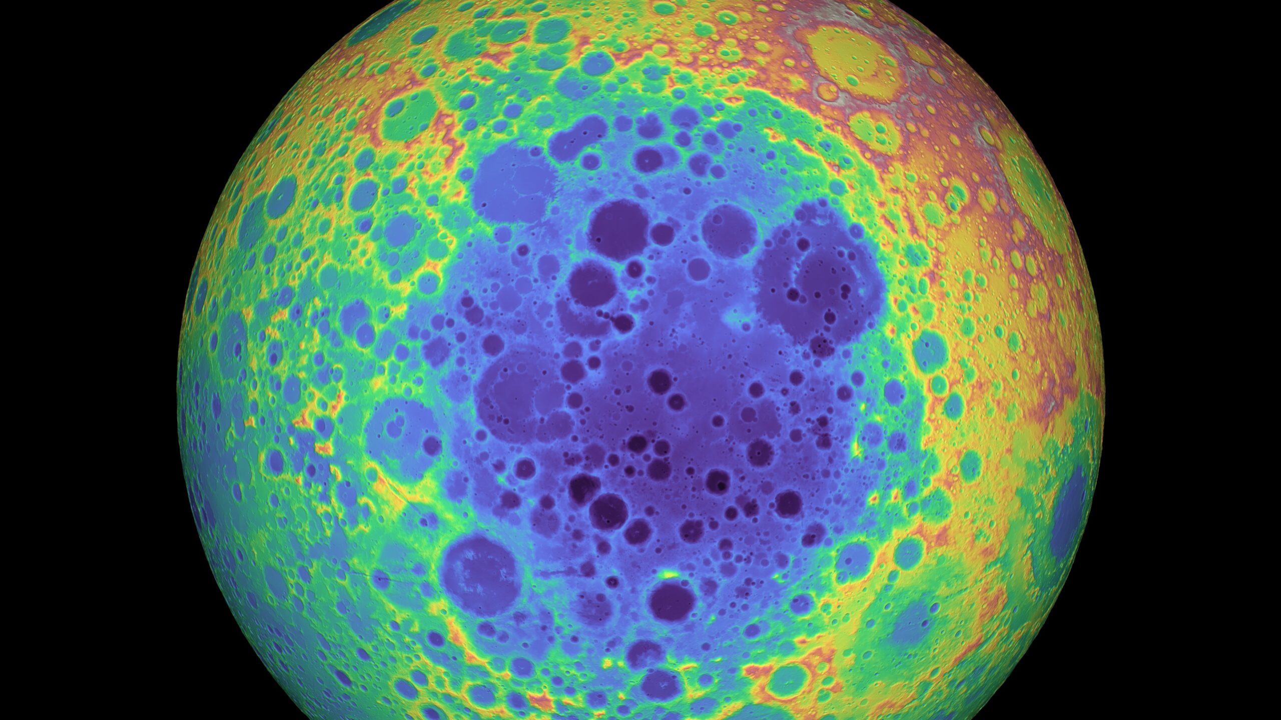
The South Pole-Aitken Basin on the lunar far side is one of the largest and oldest impact features in the solar system. It’s easily seen in the elevation data. The low center is dark blue and purple. Mountains on its edge, remnants of outer rings, are red and yellow.
Graphic Credit: NASA
“There’s a renewed interest in the Moon and of course it’s there because the potential of water,” Sen. Nelson said. “And if there is water in enough abundance, then you have the potential for hydrogen and oxygen, which would fit in very nicely with why we’re going back to the Moon this time after a half century. We’re going back to learn to live in a deep space environment for long periods of time so that we can go to Mars and return safely.”
The water ice, scientists believe, could be melted to supply astronauts with water, the hydrogen and oxygen could be separated to provide astronauts with oxygen, and those components could also then be used as rocket fuel in establishing a long-term human presence at the Moon and for eventual human missions to Mars.
In 2022, NASA identified 13 candidate landing regions near the lunar South Pole. The regions, concentrated on crater rims and flat areas, contain multiple potential landing sites for Artemis III. The regions include the rims of Faustini, Amundsen, and Nobile, a peak near Shackleton, and an area at Haworth.