


Surface Water and Ocean Topography Project Manager Parag Vaze discusses the first global survey of Earth’s surface water.
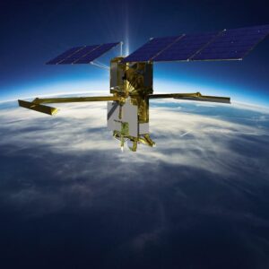
The U.S.-European Surface Water and Ocean Topography (SWOT) mission is designed to view Earth’s oceans and surface water with unprecedented clarity. The SUV-size satellite was launched in December 2022 from Vandenberg Space Force Base in Central California. SWOT is a joint mission developed by NASA and the French space agency Centre National d’Études Spatiales (CNES), with contributions from the Canadian Space Agency and the UK Space Agency.
In this episode of Small Steps, Giant Leaps, you’ll learn about:
- SWOT systems, subsystems, and science instruments
- Lessons learned and takeaways for project managers
- SWOT’s anticipated boost to scientific understanding
Related Resources
Surface Water and Ocean Topography
Joint NASA, CNES Water-Tracking Satellite Reveals First Stunning Views
Ka-band Radar Interferometer (KaRIn)
SWOT Eyes Earth’s Surface Water
APPEL Courses:
Managing NASA Research and Technology Projects (APPEL-vR&T_PM)
Requirements Development and Management (APPEL-vREQ)

Parag Vaze
Credit: NASA
Parag Vaze is the Manager of the Surface Water and Ocean Topography (SWOT) and Sentinel-6 projects at NASA’s Jet Propulsion Laboratory (JPL). Vaze has been at JPL for more than 25 years and has held technical and project management positions with growing levels of responsibility in areas ranging from telemetry system development, command and control, flight software, and mission operations to avionics, electrical ground support equipment, and project systems engineering. He has supported many Earth Science Altimetry projects, including TOPEX/Poseidon, Jason-1, Jason-2, Jason-3, SWOT, and Sentinel-6. Vaze is a member of the International Astronautical Academy and has received numerous NASA and JPL outstanding engineering, leadership, project management, and public service awards. He is also the Chair of the International Astronautical Federation’s Global Earth Observation System of Systems subcommittee. Vaze holds a bachelor’s in electrical engineering and a master’s in software engineering from Azusa Pacific University.
Transcript
Parag Vaze: SWOT is really a research mission. The technologies and measurements that SWOT is going to be doing, for many aspects, is a first of a kind.
To be able to make this kind of measurement at the accuracies and coverage that we’re making is something that’s never been done before, and that’s required numerous technologies, not one, but multiple technologies to come together.
Deana Nunley (Host): Welcome to Small Steps, Giant Leaps, a NASA APPEL Knowledge Services podcast where we tap into project experiences to share best practices, lessons learned, and novel ideas.
I’m Deana Nunley.
In celebration of Earth Day 2023 on April 22, our focus today is on an Earth Science Mission.
Surface Water and Ocean Topography, or SWOT, is a satellite mission that will make the first global survey of Earth’s surface water, observe the fine details of the ocean’s surface topography, and measure how water bodies change over time.
Our guest is Parag Vaze, SWOT Project Manager at NASA’s Jet Propulsion Laboratory. Parag, thank you for joining us on the podcast.
Vaze: Happy to be here. Really excited to talk about the SWOT mission.
Host: Could you give us an overview of the mission?
Vaze: Absolutely. So, SWOT is, as it stands for, Surface Water and Ocean Topography. The keywords in there are all about water. And SWOT is NASA’s next-generation water mission. NASA has been conducting measurements of the ocean for decades, looking at all of the salt water, so to speak, across the Earth. And those kinds of measurements have been going on, primarily looking at small areas of the ocean, really, really precisely and looking at that consistently over decades, and that’s helped to understand sea level change and other climate change information that the oceans are so important in driving as a key factor of climate variability.
SWOT is looking to take that to the next generation in almost every aspect, in terms of technology, in terms of the measurement we’re doing, in terms of the coverage we’re doing. And the goal with SWOT is not only to look at the ocean now at much finer scales. The ocean is a really big place, so even with satellites, we’ve been taking and really observing only really small tracks of the ocean. With SWOT, we plan to observe much more of the ocean and at much higher resolution in terms of observing the ocean dynamics that we’re currently just missing and scientists believe are a major factor in really understanding a lot of the climate variability, but also a lot of the societal activities that happen with regards to the ocean and the coastline.
And then SWOT takes that one step further, and not only looking at observing the oceans, but looking at the freshwater, all of the major water bodies on the surface, the solid surface of the Earth. So, we’re talking about lakes, rivers, reservoirs, and basically any major water body that the satellite can observe, which in our particular orbit, we should be able to observe about 90 percent of all of the Earth’s surface waters.
So the goal for SWOT is, of course, to observe where the water is, where it’s coming from, and where it’s going. It’s not going to answer every and all questions, but getting that data for the community, and particularly for the freshwater, which is data that just doesn’t exist, we think is going to be a breakthrough in terms of feeding the scientific engine that’s going to help in many different aspects of everyday life now and hopefully in the future.
Host: What was involved in formulating the concept and developing partnerships to make this happen?
Vaze: So, a mission like SWOT has taken a very long time in formulating, so the mission has been in work for almost 20 years. I’ve been involved, myself, for almost 20 years in developing this mission and executing the mission. And it really starts at the ground level, so to speak, with the scientific community. The science community, luckily that we had already in place across the world looking at the world’s oceans, really, we saw that this is a global problem and needs a global solution.
So first, that science community was already working together from many different countries, tens, if not more, of different countries with scientists that were working, sharing data, collaborating on different measurements and modeling and research that was going on. As that was going on, I think the understanding of what was missing kind of came out of this scientific community, and ultimately, NASA looks towards the U.S. academies, scientific academies to produce a decadal survey of the scientific priorities that NASA should be pursuing. And that global science interest, I think, really fed into the decadal survey that took place in 2007 for SWOT, where SWOT was identified, and this measurement technique was identified as a key priority for NASA to pursue.
That was just the start of it, of course, in terms of understanding, ‘OK, this is something that’s important to measure, and a high priority for the United States and the global community.’ But really taking that and understanding what sorts of instrumentation you actually need that can actually provide those kinds of measurements was a study that was started and led with NASA. And a key partner in this for many decades in the ocean remote sensing has been with several different agencies, space agencies in Europe, particularly the French Space Agency, which has been a key partner with NASA in this type of research.
So, it was decided that this is really a big issue, one that probably is going to need a sophisticated global space-based monitoring system, which should be looked at with a global solution and a partnership. And NASA pursued that with particularly the French Space Agency CNES. And since then, we’ve been working together and basically taking the really big objective and kind of building it into smaller pieces on what sort of measurement could achieve this objective. Then taking that and looking further at what sorts of technologies actually exist or could be developed. And then ultimately, putting together an architecture for a space-based mission that could achieve these objectives and then implement it. So, it’s taken almost 20 years from sort of seed to implementation to now flight. It really is a global challenge and a global contribution now towards tackling that challenge.
Host: And so many people working together to make this happen. Could you describe the SWOT systems, subsystems, and science instruments?
Vaze: Yeah, absolutely. So, there’s multiple components of the mission. First, there’s, of course, this engineering planning sort of activity that the projects do, and we’ve been working together as a project on the NASA side and also with the CNES partnership as a joint project towards this. But ultimately, it involves developing several major systems of the mission. One is the flight system, which is basically the satellite, and that, of course, is the centerpiece of the mission in terms of doing the actual measurements that we need for SWOT.
But it’s only one of the pieces that that’s needed. There is, of course, the launch system that’s needed to get the satellite into space. And then there’s a very large ground system, and that ground system is quite extensive for a mission like SWOT, where we’re not only in charge of taking and getting the data back down from space, but then converting that data into data products and circulating those data products properly and efficiently as much as we can to serve our community.
It takes an extensive amount of development, and particularly for SWOT, that requires almost all new, brand new science and science algorithms that actually convert these measurements into useful data products. So, there’s another major element to the project, which is the science algorithms and calibration validation. Once we get all of this data, and we really need to make sure that that data is valid, so we develop a pretty extensive set of other measurements on the ground, which basically look at the satellite data and the ground data and do a comparison and verification validation. Because ultimately, this data is only useful if people can actually rely on it and understand its behavior so that they can actually utilize it in their studies for research or applications or operational applications that we have.
So there’s multiple facets to the mission, and the satellite is, of course, the most visible, but there’s a huge infrastructure that is behind it on the planet. And ultimately, the science community also, and the user community is key to that in terms of engaging all of those people. SWOT is going to produce a huge amount of data. So, we’ve also been faced now with a challenge of, ‘How do we get this data out to the community? How do we make it so that it’s accessible and useful and also serves the different kinds of users that we have in an efficient manner?’
Host: And talking about the science of SWOT, how will this mission boost scientific understanding?
Vaze: Yeah. So, SWOT is really a research mission. The technologies and measurements that SWOT is going to be doing, for many aspects, is a first of a kind. So our user community is primarily the research community. The research community is looking at, of course, taking data, not just from SWOT, but from many other sources, both land-based and also satellite-based for many different aspects truly to try to understand and tackle this question I mentioned earlier about where the water is, where it’s coming from, and where it’s going.
And that has users for many different scientific thematics, whether they’re looking at local issues that might be along coastlines, that might be looking at more on what’s happening with the ocean aspects. And there, a lot of it is actually creating models. If you see, every day, I think we all rely on weather forecasts. Those are almost completely driven by models, and in terms of how good those forecasts are, are based on understanding the physics of what’s going on, and also getting the latest data that feeds that. So, SWOT is going to feed, not only those models in terms of driving them, but also in terms of creating the understanding and the algorithms that support those forecasts, which are super important, essentially, to be able to come up with forecasts of the ocean, just like what’s happening in the atmosphere that we rely on almost daily.
And then there’s other users, again, that could be geographically correlated where users want to look at freshwater data and understand what’s happening in rivers, reservoirs. Water managers want to understand what’s happening and being able to forecast how much water they have, being able to forecast how much water they think they will have. There’s agriculture that’s related to that. There are all sorts of fishery and coastal applications in terms of erosion and understanding what’s happening in the coast.
So, there are a varied set of users that are interested in getting that SWOT data. Ultimately, our best success and hope would be that this data is used, not only for that forecasting, but also for actually near-term operational kinds of uses, like being able to tackle what’s happening with flood events, or severe hurricanes that affect our coastlines, pollution that is being tracked in the oceans, water navigation that happens on ocean and on rivers, being able to help manage fisheries better. All of this data from SWOT will definitely enable much better understanding what’s happening now, but ultimately, be able to help understand and predict what’s going to happen in the future.
Host: What would you say is remarkable about this new satellite?
Vaze: So, at JPL, we have this motto about ‘Dare mighty things,’ and I think that’s fully applicable for SWOT. Because to be able to make this kind of measurement at the accuracies and coverage that we’re making is something that’s never been done before, and that’s required numerous technologies, not one, but multiple technologies to come together. And the satellite, as I said, is a centerpiece of that, which has a lot of these technologies packed in, mostly on the science instrument side of the satellite. But even the overall satellite, to actually be able to perform this measurement from space is something that requires a lot of stability and a lot of power. Those are the two things that really drive this satellite design and enable this measurement. And then there’s a lot of technologies on the ground, which aren’t as visible as the satellite, but are absolutely key to produce the data products and information that SWOT hopes to provide.
The satellite really is two main pieces. There’s one piece that’s called the platform, or spacecraft bus, which is provided by the French Space Agency. That is basically providing us all of the resources that the scientific instruments need, whether it’s power, pointing, stability, all of those things come from the spacecraft bus. This particular bus is quite powerful in having a large set of solar rays, because the payload, the scientific payload, needs lots of power and lots of stability. So, the systems are designed to be extremely stable, basically not move and perturb the science measurement.
And then the science payload, which consists of about six instruments, science instruments, and several other supporting equipment that was all provided by NASA and developed at JPL. So, the key instrument that’s really for SWOT is what we call the KaRIn instrument, the Ka-band Radar Interferometer. That is the key instrument that’s enabling this new measurement technique. That technique is something that we actually leveraged originally from a prior NASA mission that was flown on the shuttle that looked at doing topography, which is basically measuring heights.
And at that time, that instrument demonstrated that capability for the land surfaces, so the solid land surfaces. And I think scientists and engineers here figured out that this is something that might be useful over the water, so we’ve been developing that. And the key to that is being able to have two antennas that are separated by a fairly long distance, 10 meters, so about 30 feet that are deployable, and then having a radar that’s transmitting pulses down to the surface of the Earth, reflecting off the water bodies, and then being received simultaneously in these two antennas.
And that technique has been used before, but never for this specific application, and never for these kinds of accuracies and precisions that we’re looking for in our measurement. So, the KaRIn instrument is really where a lot of the new technologies we have on board, we’re producing a tremendous amount of data that the radar is producing when it’s running continuously, about 300 megabit per second continuously.
So, one of the new technologies we have is because we can’t capture all of this data and send it down to the ground all at once, the ocean data is actually processed on board. We think that’s one of the first applications of that technology. And then the freshwater data that we’re taking, that’s something that’s very new, and we’re downlinking that data directly to the ground. To do all of that downlinking, we developed a custom telecommunication system, an X-band system to get one terabyte of data every day. So, getting this enormous amount of data every day continuously translates into petabytes and petabytes of data that has to be processed, circulated, and distributed. So, it all links between the flight system and the ground system.
The other instruments we have on board the satellite relate to looking at the water vapor content as the radar signal comes through the atmosphere, and helping to correct that and make it more accurate. We have a radiometer for that. We have a traditional altimeter, which has been our traditional kind of instrumentation provided by the French Space Agency, and that helps us give a good comparison of the legacy heritage technology with the new technology flying on the same mission. And we can compare that very well.
And then we have several additional instruments that are used to very precisely know the position of the satellite itself. Because as the radar is transmitting and collecting the returns of the signals from the surface of the Earth, we need to know very accurately where the satellite is located. So, these instruments help give us a precise orbit determination, and with all of that together, we can, ultimately, make the combined measurement that SWOT is all about.
Host: Parag, let’s talk about lessons learned. Approximately four months since launch, you’ve had some time to reflect. From a project management standpoint, what do you think the team got right?
Vaze: Getting these technologies in place is a big challenge, and I think what the team got right is, ultimately, if you’re going to tackle a difficult problem, you do need to have the best tools and solutions at hand, even if they are difficult. Supplying these technologies has been quite a challenge by itself. So I think grabbing the moment when it’s right to be able to take on challenges is something I think the team got right in the sense that, let’s say, we could have gone for an incremental change, and that probably would’ve taken decades, but NASA and the project teams and our partners really decided to take that leap and go for it. And having that commitment behind taking those challenges and those risks that go with those challenges is something I think that the global team got right. It, of course, caused a lot of stress in terms of being able to execute those things, but I think the rewards are coming in, and people are really now excited about being able to meet those challenges they only dreamed of 20 years ago.
Host: What would you do differently if you had the chance?
Vaze: So, I mentioned about the technologies and the international collaboration. I think both of those are super critical. I think we had to take that window of opportunity to develop the mission, but I think if we had additional time and resources to develop those technologies, specifically for SWOT, not just in general, but specifically for SWOT in advance and have an on-ramp, that would’ve definitely made things easier and packed less of an intensive effort during the mission implementation.
And I think also, the engagement with the community is super important. COVID really threw another big challenge our way in the last two years, where just as we were reaching the critical phases of developing and integrating and testing the mission elements, COVID came at us, and we reacted. We overcame that. But being able to have that connection between all the teams is something we missed and I think is something we would in hindsight and in the future, we’ll definitely want to spend more time and nurture going forward.
Host: Well then, along that line, do you have advice or takeaways from managing this Earth science mission that might be helpful to other project managers?
Vaze: So, I think working Earth science missions is something that’s very rewarding. And that reward comes from really tangible results that we see. So doing these individual missions, and I’ve managed five Earth science missions — SWOT is my latest one — and every single one of them has a definitive reward that you see in result that you see in everyday life. And the utility of that data is something that is super rewarding from Earth science.
But the second thing is that, just because it’s Earth science and there are lots of satellites flying around, that doesn’t mean that it’s routine. There are these challenges that we have, and I think applying those breakthrough technologies for Earth missions is actually the first step towards applying them elsewhere. I’ve seen multiple Earth science mission technologies demonstrated with Earth now, and now being applied in outer planets and Mars, the Moon, and many different places. So having that reward and that sacrifice does pay off. And also, the challenge is no small feat for Earth, just because we have more experience on the Earth.
Host: What’s the SWOT timeline going forward?
Vaze: So, SWOT launched on December 16, ’22. That was a long time coming, and the team really worked hard to get to that point. Since then, we have been in, what we call this commissioning phase, where we’re basically turning on all of the major systems in orbit and on the ground and checking them out and tuning them, so to speak. We’ve done that, actually just recently completed that phase as planned, where we had planned to complete it, let’s say, within the first three months of the mission.
The next three months are devoted towards calibration and validation. So right now, SWOT is in a unique, what we call one-day-repeat orbit. We’re not in our final science orbit. And that was really chosen specifically for SWOT, because we want to devote, as a brand new measurement, the best opportunities and best instrumentation we can have to actually calibrate and validate the measurement results we’re getting back from the satellite. So we just started that activity.
We have, of course, the satellite flying and operating, but we’re overflying many different locations across the world, where we have instrumentation and teams that are out in the field, setting up ground-based instrumentation and water-based instrumentation. So we have teams, for example, out off the coast of California, setting up buoys and moorings out there. So that as the satellite overflies that, we can crosscheck the measurements we see literally on the ocean versus what the satellite is telling us.
And then we have other teams, because SWOT is all about water, in all kinds of areas of the Earth. So, we have people out on rivers in the U.S. and Canada, in Europe, and you name it, in Asia and New Zealand. And it’s really an international effort that organizations, some of them have just joined the SWOT team and put their resources and equipment out there to measure what they observe with the satellite overflying. So that’ll go on, basically, for the next three months through the end of June is our plan.
And then we boost into our final science orbit, which is a 21-day-repeat orbit. So basically, every 21 days, we’ll be coming over and building a complete map of the Earth coverage. Of course, we’ll be covering and overflying certain parts of the Earth much more frequently. So we’ll start our science mission, let’s say, approximately beginning of July. And it’s planned to go on for at least three years, and that’s our objective.
And part of that is to observe, of course, what’s happening in the ocean, but seasonally, particularly in the freshwater aspects, a lot of the dynamics change as the seasons go. We have winter freeze-thaw cycles, so a lot of these water bodies will freeze, will melt, will move, and SWOT wants to observe those behaviors over several different seasons and cycles. Now, the measurement is still brand new, so there will be an ongoing calibration validation, science validation activities. I mentioned some of them going on right now. But many of those things will continue for the life of the mission, because there’s just a huge unexplored territory, so to speak, that we’re going to be getting measurements just first of a kind, first ever, particularly from space. And we’ll be wanting to understand what we’re observing and also checking that what we’re observing makes sense as we continue the mission over the full life of the mission.
Host: What excites you most about SWOT?
Vaze: So, SWOT is very exciting to me. In challenging the team in almost every aspect, programmatically, it’s been very interesting and rewarding to be able to build the mission, but also build the partnership. That’s extremely rewarding to see that we can combine our efforts, truly looking at what we’re best at, whether it’s in the United States, Europe, Canada, and many other places, and truly join hands and jump into this mission and see how we can collaborate.
But the technology aspects from an engineer, I’m an engineer, so building these kinds of technologies is not only going to enable this new measurement for SWOT, but we think enable people to leverage these technologies for many other new measurements that we think are really going to make a difference. And ultimately, I think making a difference for our planet and our humanity and seeing this mission contribute to the current events and the current challenges that the world is facing is very rewarding in terms of making a contribution towards helping solve those complex problems.
Host: Many thanks to Parag for joining us on the podcast. You’ll find his bio and links to related resources on our website at APPEL.NASA.gov/podcast along with a show transcript.
If you’d like to hear more about what’s happening at NASA, we encourage you to check out other NASA podcasts at nasa.gov/podcasts.
As always, thanks for listening to Small Steps, Giant Leaps.