


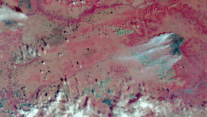
Within days of the launch, Landsat 1 acquired an image of an astounding 81,000-acre fire burning in isolated, central Alaska. For the first time ever, scientists and resource management officials were able to see the full extent of damage from a fire in a single image while it was still burning.
Photo Credit: NASA/USGS
Landsat 1 demonstrated the value of multispectral scanner technology.
In the mid-1960s—even as NASA was sending spacecraft to make the first passing observations of Venus and Mars and developing the program that would land humans on the Moon—the agency began working with other government organizations to explore how remote sensing technology on satellites orbiting the Earth could contribute to the fields of geology, hydrology, geography, and cartography.
This work came to fruition in the summer of 1972, when NASA launched Landsat 1 aboard a Delta 904 rocket from Vandenberg Air Force Base, outside Santa Barbara, California. The July 23rd launch—51 years ago this month—began a highly successful partnership with the U.S. Geological Survey (USGS) to gather detailed information about Earth’s landmasses and water resources from space.
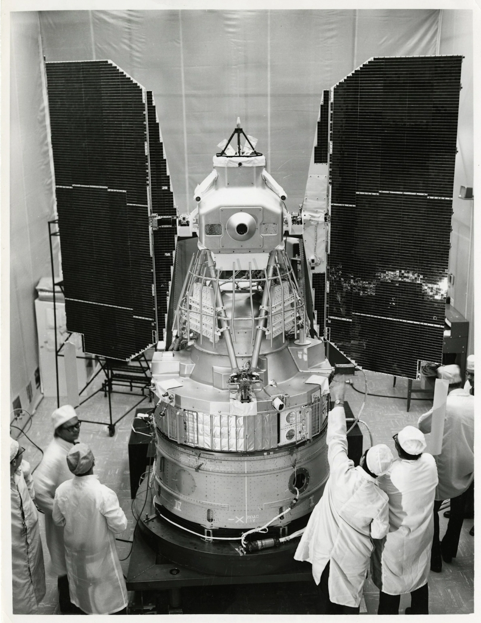
Landsat is shown in flight configuration with solar panels deployed after tests at the G.E. Valley Forge Plant.
Photo Credit: NASA
Landsat 1 was built on a satellite bus like those used in NASA’s successful Nimbus weather satellite program. The finished product was nearly 10 feet tall with a diameter of 4.9 feet. The satellite was equipped with three hydrazine thrusters and an attitude control system to keep it properly oriented toward Earth. On orbit, the satellite deployed two solar panels to generate power for the instruments on board.
The satellite’s primary instrument was a Return Beam Vidicon (RBV), an instrument similar to a traditional television camera, employing lenses, shutters, and cathode ray tubes to take full frame images of a target below. The technology was proven and had performed well in space in earlier applications.
The spacecraft’s secondary instrument was an experimental application of a Multispectral Scanner System (MSS). The MSS aboard Landsat 1 gathered data in four different spectral bands—green, red, and two bands of near-infrared—and transferred it to the ground as real-time, binary data. This new technology had been tested on Earth but was unproven in the harsh conditions of space.
Pioneering aerospace engineer and physicist Virginia T. Norwood took on the challenge of adapting multispectral scanner technology for space applications. Norwood, who worked for Hughes Aircraft Co., took a user-based approach, meeting with the university professors, meteorologists, geologists, hydrologists, cartographers, and government agencies who would ultimately use the data from Landsat 1.
“I had to talk to people in all kinds of disciplines that I had no idea about before, so I found it utterly fascinating,” Norwood recalled in a 2020 interview in which she discussed the challenges of the project. “This was space—no air, no gravity, significant distances for data signals to travel—it was all new,” Norwood explained.
Faced with a mass limit of about 100 pounds and a short deadline for development and testing, Norwood set about designing an MSS that met the expectations of future users while still fitting within the tight limits of Landsat 1.

Virginia Norwood, the mother of Landsat, in 1963 with slide rule. Norwood’s father gave her her first slide rule at age 9, by the late 1960s she was designing the groundbreaking Multispectral Scanner System (MSS) for the first Landsat satellite.
Photo Credit: Hughes; used with permission of Virginia Norwood.
The design was optimized for space, with a small beryllium mirror moving back and forth between two bumper stops, carried by inertia. The mirror directed the light reflected by Earth to sensors in four spectral bands. Images were built six lines at a time, with each pass of the mirror adding new lines and the movement of the satellite advancing the image. Images and calibration data were transmitted to the ground digitally in 6-bit encoding.
Although an engineering model was mounted on a truck and driven across California for image testing, it wasn’t until the MSS was on orbit and returned the first images to Earth that skeptics of the new technology were convinced.
In fact, images from the MSS were so impressive that it quickly became the primary instrument of the mission—a decision that was cemented after the RBV was the source of an electrical anomaly in August that briefly caused the satellite to lose altitude control. The RBV was powered down.
Landsat 1 orbited Earth every 103 minutes, which amounts to 14 orbits a day, with an 18-day repeat cycle. It began returning valuable science immediately, including images of a fire burning 81,000 acres of land in a remote area of central Alaska, giving officials the first ever look at boundaries of such a large fire as it was burning.
It easily exceeded its one-year design life, returning data until it was decommissioned in January 1978. By that time, Landsat 2 had been on orbit for nearly three years, with Landsat 3 progressing toward a launch date of March 5, 1978. In 51 years, Landsat satellites have given researchers an ever more detailed and evolving picture of Earth, recording the devastation and recovery of the volcanic eruption of Mount St. Helens, the shrinking of the Aral Sea, the retreat of the Columbia Glacier in Alaska, and the loss of tropical rainforests.
Landsat 9 was launched on September 27, 2021, joining Landsat 8, which has been on orbit for more than 10 years. Landsat data is free to the public. To learn more about the program and to access that data, click here.