

NASA Water Resources and Agriculture Program Manager Brad Doorn discusses how NASA tools and data help solve big problems on Earth.
Farmers and others regularly make decisions about water management, planting, and market decisions based on NASA data delivered by partner agencies and organizations, such as the U.S. Department of Agriculture. Data from NASA’s Earth observation satellites and science research help inform crop conditions and provide information to prepare for changes such as longer and deeper drought and more intense, severe weather. The Applied Sciences Program in NASA’s Earth Science Division provides support and funding to help institutions and individuals make better decisions about food, water, health, safety and the environment.
In this episode of Small Steps, Giant Leaps, you’ll learn about:
- The use of NASA satellite data to assess food supply
- The importance of NASA Harvest in bolstering global food security
- The influence of the latest NASA missions and tools on the future of farming
Related Resources
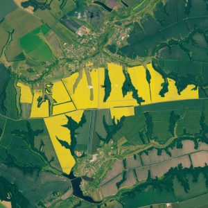
OpenET: A Satellite-Based Water Data Resource
Soil Moisture Active Passive (SMAP)
Global Precipitation Measurement (GPM)
Surface Water and Ocean Topography (SWOT)
Gravity Recovery and Climate Experiment (GRACE)
Episode 25: NASA Technology Transfer (Small Steps, Giant Leaps)
APPEL Courses:
Communicating Technical Issues (APPEL-vCTI)

Brad Doorn
Credit: NASA
Bradley Doorn is the Water Resources and Agriculture Program Manager at NASA Headquarters. Doorn leads a NASA team of water and agriculture applied research experts who coordinate a national community of funded researchers, collaborations with decision makers, and partnerships with NASA research, satellite missions and education. Prior to joining NASA, he was the Division Director of the International Production Assessment Division in the Office of Global Analysis, Foreign Agricultural Service, U.S. Department of Agriculture (USDA). Doorn served on active duty for nearly 10 years as a U.S. Army Corps of Engineers Topographic Officer, including Company Commander of the 175th Topographic Company in direct support of the XVIII Airborne Corps and Fort Bragg, North Carolina facilities, and entered the Retired Reserve in 2010 at the rank of major. He holds a bachelor’s in geological engineering from South Dakota School of Mines and Technology and master’s and doctoral degrees in geodetic science and surveying from The Ohio State University.
Transcript
Brad Doorn: Providing satellite data for everyone to use that has clear food production information in it is really a benefit to everybody. It is one of those neat things that really shows the value of satellite imagery.
Deana Nunley (Host): Welcome to Small Steps, Giant Leaps, a NASA APPEL Knowledge Services podcast where we tap into project experiences to share best practices, lessons learned and novel ideas.
I’m Deana Nunley.
As people around the world get ready to celebrate Earth Day April 22, we’re looking at ways NASA’s Earth Science Division uses unique global observations to help us better understand our home planet’s interconnected systems.
Brad Doorn from the Earth Science Division’s Applied Sciences Program joins us to discuss NASA’s role in agriculture. Brad, thanks so much for being on the podcast.
Doorn: Oh, this is wonderful. I love talking about what we do here at NASA, so thanks so much for reaching out.
Host: Oh, absolutely. From your perspective as Program Manager for Water Resources and Agriculture, and in line with this year’s Earth Day theme, what is NASA doing to invest in our planet?
Doorn: I think one of the most exciting things we do is when we invest in our satellites and our technology and our science, we are thinking about the needs of society. One very big one is our food supply, our agriculture system. I don’t think there’s ever been a time when we need more information. We need more high-level, decision-making information, and I think NASA is sitting with such great resources to provide essential information to decision makers from the farmer all the way up to nations and even multiple nations to make decisions about the food supply and make sure food is available to everybody.
Host: Could you tell us more about NASA’s role in agriculture?
Doorn: Sure. The really neat thing about NASA and agriculture is it’s one of the oldest missions that we have. Our Landsat mission was essentially started during an agriculture / food supply crisis. And this year we’re celebrating 50 years of Landsat data. So, it’s almost as old as NASA itself. In the early 70s, we did have a crisis. We had a crisis where we had a food supply crisis. We had a crisis in our energy systems, and one of the big reasons was we did not know what was going on in major parts of the world. At that same time, we happened to have this ERTS satellite, which later became Landsat 1. The U.S. government said, ‘Hey, we’ve got some capabilities to help resolve this problem.’ And for now five decades, we’ve been using Landsat and now many other satellites to assess the conditions of food supply around the world.
As you might know and the audience might know is we have a food supply that is a global system, unlike water, where the water we use is the water that we have locally. We are eating foods from across the globe, and our food in this country goes across the globe, so understanding that entire system — almost like a natural system, almost like the weather — we understand that system. We need to know what’s going on in all parts of the world, and we have satellites that can do that. To this day, we’ve been supplying data to the U.S. Department of Agriculture, to international agencies including today NASA Harvest provides data to the G7 countries, including the Food and Agricultural Organization of the United Nations in order for them to stabilize food prices, to make food more secure, to make exports more stable. And the COVID crisis and now all the crises around the world really show the need for that information.
Host: In addition to Landsat, what are some of the key NASA missions and projects associated with agriculture?
Doorn: Anything related to weather is critical, so our GPM Mission, our precipitation mission, anything related to water itself, for instance, our SMAP mission related to soil moisture, one of the most critical data sources that we have for agriculture productivity. And now, we’re going to have more with our upcoming missions like SWOT and NISAR are going to provide even better levels of surface water information and of soil moisture information. So, it’s hard to determine a satellite that’s not important to the agriculture industry.
Of course, we spend a lot of time with our MODIS and our VIIRS sensors that have a lot of information on vegetation and vegetation productivity, so that gets a lot of the attention and for good cause. But, there’s a lot of other data sources that provide essential information that help us predict what a crop may be. Many of our stakeholders, they don’t necessarily need us to tell them what the yields may be in an area at harvest. They need to know, at planting time, ‘What are the risks, what are the potential yields?’ In that case, you have soil moisture, you have weather forecasts. Lots of different information is needed, and we have a lot of sources.
Host: You mentioned NASA Harvest earlier. Could you tell us more about NASA Harvest, and how important is it in bolstering global food security?
Doorn: Let me take one step up from NASA Harvest. I’m part of what’s called the Applications Research Program of NASA in the Earth Science Division. Applications is all about relationships. It’s about partnerships, because what we’re trying to do is tie these satellites that we have and all this science that we have and trying to collaborate with an end user that’s actually making decisions, whether it’s a farming organization, a water resource organization, an agriculture producer. In so doing, we try to figure out what’s the best way. What are the best partnerships that we can have?
NASA Harvest is, in essence, an experiment in taking a large chunk of an Applied Sciences Program and providing it to a consortium. It’s this big network of organizations that all get together and try to team up and resolve problems. NASA Harvest has in its work now with the G7, with the Agricultural Market Information System, which is trying to help stabilize food, food supply, food prices around the world, is teaming with international agencies, with United States Department of Agriculture, with USAID, our aid agencies, in order to provide information on a monthly basis that can help provide information that may be critical to exports, to imports, to crisis situations like we have around the world today, so that those that are importing, those that are exporting, and those that are consumers can feel ‘OK, I understand the problem, and here are my options.’ Understand the risk, so that there isn’t this vulnerability, this instability caused by uncertainty. That’s what we try to resolve.
NASA Harvest has essentially pulled that team together and then use this, then, also to address things like issues in the developing world, food-insecure nations. It’s really a platform that allows us to reach out to multiple different partners that may have different situations.
Host: Looking at different situations and the changing landscape of our food and water supply on Earth, what are some of the changes and challenges that are getting your attention?
Doorn: Well, I think that the challenges and one of them that NASA Harvest has jumped on just recently is that while providing the information about food supply and food production in particular areas of the world is important, we also have to know where that food is being used, who needs the food, who is that food supplied to, and so them tying the food production information to who actually needs it and who is buying it helps the decision makers understand, oh, if there’s a famine in a particular part of the world, they can go out and they can see, OK, what countries are going to be impacted, and where are my options? Maybe there’s a bumper crop in another part of the world. That can help stabilize and provide a bit more information than simply saying that, ‘OK, food supply is relatively good.’
A good example was during the pandemic, as you know, all over the news, the food supply chain and the supply chains were broken. At the same time, we actually were having across the globe, pretty good food production, food supply situation. There was a little bit of a disconnect between what we were seeing on a food production standpoint of the globe and what people were seeing in their grocery stores and what food suppliers were struggling with. We saw that as a need that we needed to close that loop a little bit better.
That is another neat thing about NASA Harvest. They’re able to jump on that. They’re teaming with former chief economists of USDA to help them do that analysis with economic organizations that help them pull that information together because that’s not our generic, physical science NASA data that we have to find. Starting to pull that together, and if you go to NASA Harvest now, you’ll see the beta version of that, where they’re able to tie that information into our food supply forecast.
Host: So, this information is available on the web for anyone to go and look at?
Doorn: Absolutely. Yep. That’s the whole point of that programming. It actually syncs in very well with the financial markets because one of the needs that they have is transparency of this information. They don’t want one particular group holding information that others may be dependent on. And so, providing satellite data for everyone to use that has clear food production information in it is really a benefit to everybody. It is one of those neat things that really shows the value of satellite imagery.
I used to work for USDA, and so in my previous mission before I came to NASA, I was helping run the food production program that actually provides satellite data to help assess the food supply around the world. One of the leaders there, one of the messages that he gave to me and others in leadership there is that that satellite imagery is one of the only direct observations he has on food supply around the world. And when you think about it, everything else is coming from secondhand sources or from news reports or maybe export ledgers. And so, it provides a bit of an independent assessment of what’s going on and helps everyone understand, ‘Are we in a crisis or are we not?’ and in a timely fashion.
I think that’s probably the big change from over the past few decades. We’re not as concerned of about that particular issue anymore. I think the issues now are one, some of these crises happen in a more rapid fashion or more dependent on global trade than ever. Now we have instabilities, and we will always have instabilities, right? And so, these data can help us adjust to these issues that come up in the world and that will always be there. It’s a nice statement on the need for space-based observations that we can all share and everyone can see.
Host: Yeah, and for the first time in 2022, NASA attended America’s largest farmer-led, farmer-focused event — the Commodity Classic. What are some of the key takeaways from that event?
Doorn: I think a couple things. One, it showed, in one sense, we still need to keep working on our messaging. There’s still this sense of, ‘NASA, oh, you do Earth science. And I didn’t realize you were using our data.’
I have a funny story. One of our scientists was browsing around the Commodity Classic and got a question from one of the, I think it was an implement dealer, and said, ‘Well, what are you doing here? Why is NASA here?’ Right behind that dealer, he was showing some data, and it was dealing with the situation in the country, and right behind it was a NASA data product, even with the NASA meatball on soil moisture across the country, and our scientist said, ‘That’s why.’ Just making that connection, and the scientist said, after that, he had such a great conversation because he was like, ‘Oh,’ and just kind of making the connection between, really, what we do and what we’re trying to do in support, not only farmers, but the agriculture industry. It was a great experience. I think that was one need we saw.
The other was really hearing the needs from the users. I think now we’re seeing the farmers with so much information. I remember one of the comments from a producer who was saying, ‘I have so much information. I get it all day long from my equipment and from the news media and from the industry. I need help in just deciphering that. Give me something that’s useful and something I can use to make decisions.’ I think that was a clear message to us to say, ‘How can we help?’ We have tools to do that, so it’s not only the observations, but it’s the ability to take all that information and turn it into something that everyone can make decisions on. That and a lot of other just great discussions.
I think the last thing is that just making the personal connections with industry, with farmers, producers, associations that represent producers and having these one-on-one chats to understand where the industry’s going, where their pain points are, what information would be provided. Sometimes we say, ‘Well, we can’t do that,’ and that’s fine. I think understanding, too, what we can’t help. Sometimes we think we can solve everything, but understanding where we can provide our value to the industry is important. So, it was a really wonderful experience.
Host: Could you give us a glimpse of the latest tools and innovative applications, and what you see as NASA’s influence on the future of farming?
Doorn: I think I’ll talk about two in particular. One is what’s called OpenET. Essentially, what it is, is a tool that’s allowing us to take primarily the thermal channel on the Landsat satellite, the thermal sensor, and use that in a way to develop a more comprehensive and complete information on evapotranspiration, which gives a critical measurement of water use, of what a plant needs in order to be healthy. When we’re in a major water crisis like we are now, especially out West and even in other parts of the country, understanding how we can use water more efficiently has been a big draw. That tool, and being able to allow users to see the data, have it integrated into irrigation management systems, so it’s not a unique, separate NASA tool. It’s a data product that can be integrated into existing decision-making tools to allow them to more effectively and efficiently use water is really, really critical.
I think sort of the evolution right now that we have is we’re really tying this all into the ability to process data like we’ve never had before. That was also a limiting factor. The sensors are getting better, and we had just launched Landsat 9 last fall, and so we have better and better satellite measurements. Then, the ability to take this information — and I talked about partnerships. And that’s a partnership with Google, with EDF, with Desert Research Institute, with organizations across the country, including our federal partners. That ability really does, then, provide the trustworthiness of the tool. By the way, that’s one of the things that we heard often at the Commodity Classic and others is NASA is a trusted brand, and we don’t want to tarnish that. We want to show why it’s a trusted brand, and it really does show.
The other product that is really growing now is this water information. So OpenET talks about sort of the water use part of the equation. The other is the water supply. For agriculture, the essential part of that is where the water touches the crop. That’s soil moisture, and preferably root zone soil moisture. We are now producing a soil moisture product, and the resolutions are getting better and better. Our new satellite, NISAR, that’s going to launch in a few years is going to get it down to 200 meters globally, except in desert regions.
Soil moisture is essentially that critical element that is needed almost throughout the growing cycle from planting conditions to emergence to right into senescence and harvest. Having that information is almost a yield forecaster, and so getting better and better information on soil moisture has been a key driver of what we’ve been doing in partnership with USDA and other agencies. We produced just recently a soil moisture product for USDA that provides that soil moisture on a regular basis to show them crop progress around the country, so they don’t have to just go reach out and get that. The soil moisture is also being used from NASA in agriculture media production. In some agriculture news forecasts that are focused on agriculture, they’re using the NASA product for soil moisture.
Those two attributes are key. They’re almost foundational. The water-use component and the soil moisture. Then, of course, all things water cycle will become more and more important as we build out more and more information, and NASA’s doing it. We have some of the most unique tools and sometimes the only observations on some of the aspects of the water cycle. We take that seriously, and we want to make sure we’re getting it out there and making it useful for everyone.
Host: And, Brad, talking more about water resource management, what else NASA is doing?
Doorn: We talked about water use, and that’ll continue to be a big issue and driver. I think one of the things I didn’t mention is we have surface soil moisture and, of course, root zone soil moisture. But, then, of course, as many of us know, we’re concerned about the drawing up of the aquifers, whether it’s the Ogallala in our Midwest or in the Central Valley of California, and we are getting better information. It isn’t perfect. But the issue with the subsurface water is we have so little information on subsurface water, even the information that we can provide through course measurements, maybe through our GRACE satellite that measures mass change and can assess the changes in subsurface water. It’s enough that it can constrain these models that allow us to really help pinpoint, ‘Are we drawing down more than that we’re resupplying?’ This type of information to help us understand this whole water cycle, and that goes right up to our atmospheric satellites that help us understand precipitation much, much better, are going to always be critical to the agriculture industry. I think they’re just going to get better and better.
Host: You told a story about Commodity Classic and the person kind of like ‘What’s NASA doing here?’ Generally speaking, do you find that people are surprised by the space agency’s active role in agriculture?
Doorn: Yeah, I think, certainly, we’ve got this strong connection at national and global levels at those agencies, but I think the industry, themselves, don’t realize sort of this story, and partly because we haven’t had the footprint at the local level. So, they don’t hear about it. I’ve always told my teams and my PIs, the best application out there is where you don’t even know NASA data is behind it, right? That it is funny, I just listened to an old podcast of yours on Tech Transfer at NASA. In one of the statements the gentleman made was that many people don’t know many of the things that NASA provides because it might be a valve or a widget here that we developed that’s in a system.
It’s almost the same with applications. Some of the most successful ones will be ones that the person takes ownership of it, the tool. Even like OpenET, the application is an irrigation management system that actually integrates OpenET into their data sets. And so, I think, because of that, sometimes they don’t see that NASA is there. We need to make sure that we’re communicating, but I also like the idea that, especially in this country where people want to take ownership of that tool, of that information, they want to make it their own, and so, having us support that, I think is a great mission.
Host: Well, I’ve certainly learned a lot today, Brad. I really do appreciate you being on the show. Thank you so much for joining us.
Doorn: Oh, thank you. I love talking about it.
Host: Is there anything we didn’t cover?
Doorn: No, this was wonderful. I love having chats like this, and I hope I was able to communicate and give a little bit of support to the team that does all the work in this area. Thank you.
Host: You’ll find Brad’s bio, links to NASA Earth Day activities and topics we discussed during our conversation, and a transcript of today’s show at APPEL.NASA.gov/podcast.
As we continue to look at observations of Earth’s interconnected systems, please plan to connect with us for our next episode May 4 when Kate Calvin, NASA’s Chief Scientist and Senior Climate Advisor, joins us on the podcast.
If you like this podcast, please follow us on your favorite podcast app and share the episode with your friends and colleagues.
As always, thanks for listening to Small Steps, Giant Leaps.