

![]()
By Ben Bruneau and Kerry Ellis
NASA’s first “blue marble” pictures of our Earth, brought back from a new frontier of exploration, opened a new frontier of imagination and understanding. They have been reproduced again and again because they give us a more vivid image of Earth’s beauty, fragility, and oneness than we had ever had before. These and other pictures from space have changed what we knew or had assumed about our planet. In addition to helping us see the world as a whole in a different way, National Aeronautics and Space Administration images provide useful, thought-provoking, and sometimes startling information about many aspects of life on Earth.
NASA’s first “blue marble” pictures of our Earth, brought back from a new frontier of exploration, opened a new frontier of imagination and understanding. They have been reproduced again and again because they give us a more vivid image of Earth’s beauty, fragility, and oneness than we had ever had before. These and other pictures from space have changed what we knew or had assumed about our planet. In addition to helping us see the world as a whole in a different way, National Aeronautics and Space Administration images provide useful, thought-provoking, and sometimes startling information about many aspects of life on Earth.
Photographs help us preserve memories, but they also help us shape opinions, make decisions, question what we know, and gain new knowledge. From choosing a hotel room to learning about conditions in other countries, photographs have long been used to teach us about other people, places, and things we may not have experienced directly. And some photographs— like those from NASA—allow us to glimpse things we would never be able to see or imagine for ourselves. Here are a few examples.

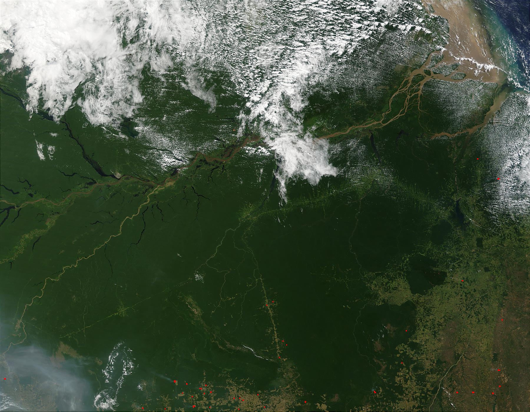
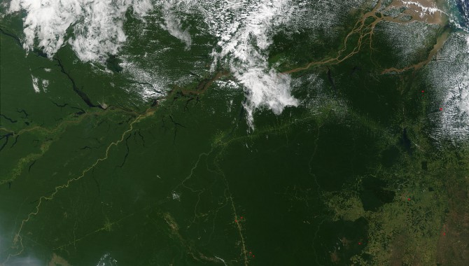
For more than thirty years, scientists have used satellite imagery of the Amazon to seek answers about Earth’s diverse ecosystem and the patterns and processes of land cover change. (footnote 1) Shown here is the Amazon Rainforest in northern Brazil as captured by the Moderate Resolution Imaging Spectroradiometer (MODIS) on July 1, 2002. At bottom right and bottom center, deforestation and cultivation are evident by the regular, rectangular shapes that delineate plots.
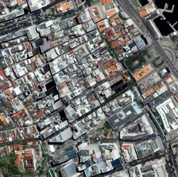
Maps taken from space are invaluable to city planners and state agencies monitoring water quality in urban areas as they provide information about city growth and how rainfall runoff over paved surfaces affects regional water quality. (footnote 2) This image, taken by the IKONOS satellite, shows one of the most densely populated cities in the world: Rio de Janeiro, located on the Guanabara Bay in southern Brazil.
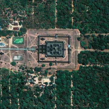
Thanks to radar technology on satellites and shuttles that can penetrate tree canopies, vegetation, clouds, and the dark of night, (footnote 3) archaeologists can study the city of Angkor in Cambodia. The Angkor complex is hidden beneath a dense rainforest canopy, making it difficult for researchers on the ground to study the ancient city. The ancient Angkor Wat temple shown here is considered one of the most valuable architectural sites in Asia. Angkor Wat, built by Suryavarman II between 1113 and 1150 AD, is the pinnacle of the city of Angkor, capital of the once- powerful Khmer Empire of Southeast Asia.
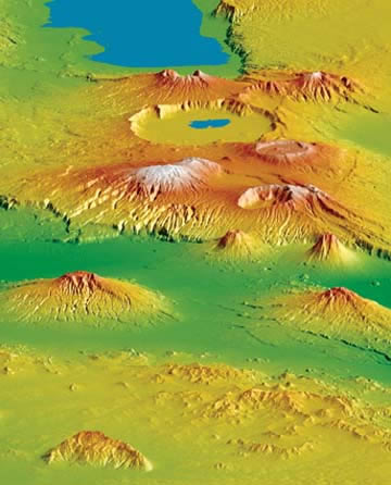
The view from space has allowed NASA to map the terrain of Earth, which has important safety implications for the aviation industry; poor visibility combined with uncertainty about terrain causes more than fifty percent of fatal aviation accidents. (footnote 4) This view of the Crater Highlands along the East African Rift in Tanzania, obtained from NASA’s Shuttle Topography Mission, shows landforms using color and shading. Color indicates height, with lowest elevations in green and highest elevations in white, and shading shows the slope.

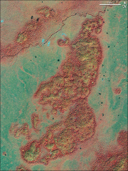
Images of Earth provide key data to the U.S. Department of Agriculture Foreign Agricultural Service (FAS), data that can be used to predict the amount of crop damage that might have been caused by natural disasters, such as flooding and volcanic eruptions. (footnote 5) In late summer 2002, heavy monsoon rains led to massive flooding in eastern India, Nepal, and Bangladesh. This combined true- and false- color image acquired by the Moderate Resolution Imaging Spectroradiometer (MODIS) aboard NASA’s Terra spacecraft shows the extent of this flooding.
On December 15, 2002, IKONOS captured this image of the remains of Mayan structures in Guatemala. In a natural-color image, the changes caused by the ruins would be hard to distinguish from the natural variation in the green forest canopy. The best way to find them is to look at the visible and near-infrared spectra, shown in this false-color photograph. In this type of image, the forest covering the ruin sites appears yellowish, because the Mayan monuments, built from limestone, affected the chemical make-up of the soil as they deteriorated.
Footnotes
1. “NASA Satellite Data Provides Rapid Analysis of Amazon Deforestation,” ScienceDaily, September 14, 2005,http://www.sciencedaily.com/releases/2005/09/050914105508.htm
[back to article]2. Lynn Chandler and David E. Steitz, “New Satellite Maps Provide Planners Improved Urban Sprawl Insight,” NASA News (May 30, 2001).
[back to article]3. “Archaeologists Dig Space,” Jet Propulsion Laboratory Feature Story, January 29, 2001,http://www.jpl.nasa.gov/news/features.cfm?feature=3.
[back to article]4. Eric Berryman, Carolina Martinez, and David E. Steitz, “Seeing Clearly Now: Sharp New NASA Maps to Improve Lives Everywhere,” NASA News (July 11, 2002).
[back to article]5. Rob Gutro, Mary Rekas, Holli Riebeek, and David E. Steitz, “NASA Satellites Improve Response to Global Agricultural Change,” NASA News, January 20, 2004,https://www.nasa.gov/home/hqnews/2004/jan/HQ_04025_agriculture.html.
[back to article]