


![]()
By Brent Cobleigh
On October 18, 2007, I received an e-mail from Thomas Zajkowski, remote-sensing analyst for the USDA Forest Service’s Remote-Sensing Application Center. It read, “Does Ikhana still have its wings? There are two ‘high-risk days’ (October 21–22) due to winds for the South Central Mountains and the Southern Mountains. If we do get a fire start, could we support it with a 20-to 24-hour mission?”
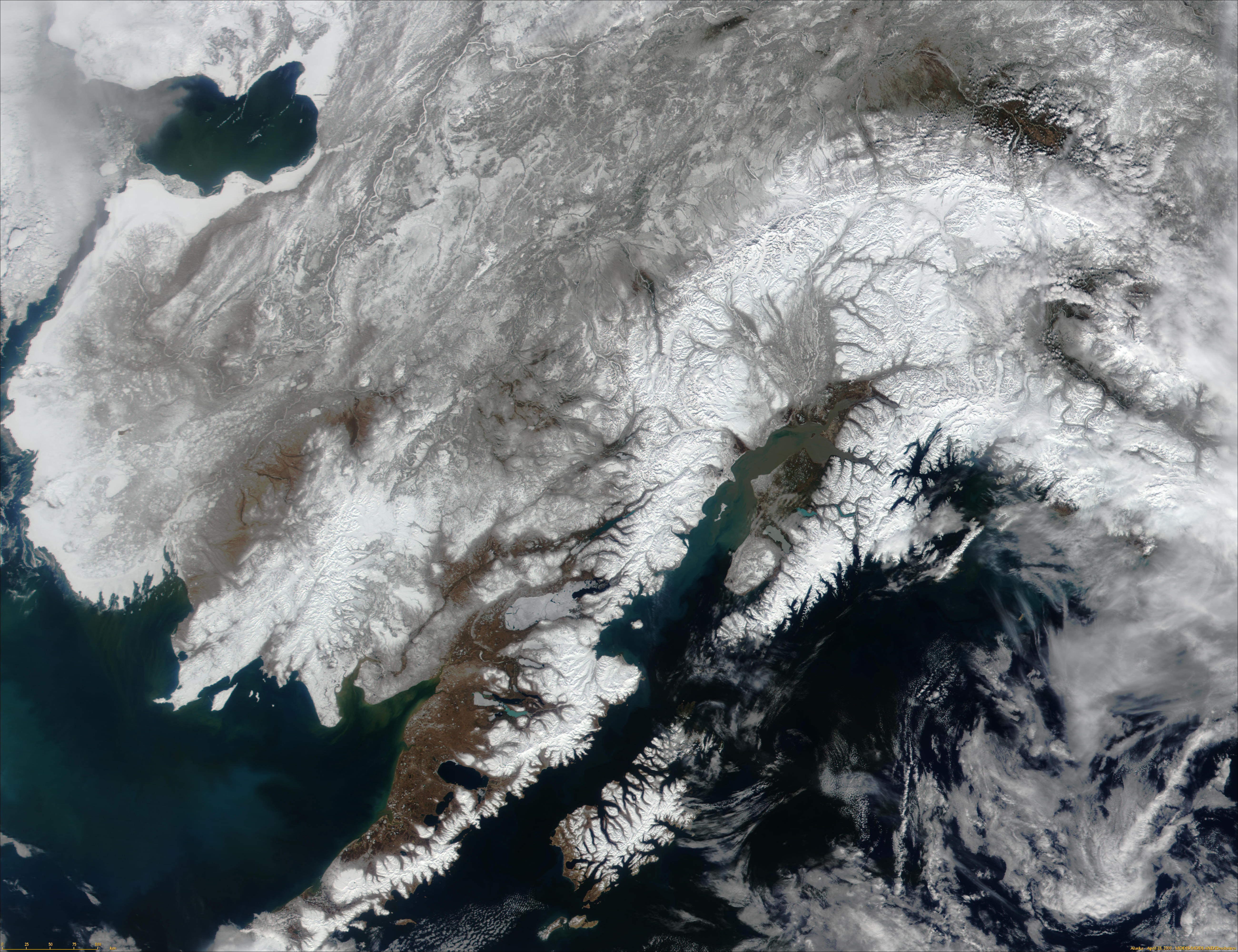
A red-flag warning had been issued by the United States National Weather Service, informing area firefighting and land management agencies that conditions were ideal for wildfire ignition and propagation in the Southern California area.

Ikhana flies a test mission with the Autonomous Modular Sensor mounted in a pod under the left wing. Ikhana is a Choctaw Native American word for intelligent, conscious, or aware.
Photo Credit: NASA/Jim Ross
During the prior year, the Ikhana team at Dryden Flight Research Center had run a marathon that started with the delivery of the unmanned science aircraft from the manufacturer, General Atomics Aeronautical Systems Inc., and culminated in the highly successful Western States Fire Mission. That mission demonstrated the advantages of using a long-duration unmanned aircraft system outfitted with an advanced infrared sensor to image wildfires in the western United States. We had met all the objectives and had already started aircraft modifications for the next experiment. So my response to Tom’s e-mail said, “Sorry guys—we held out as long as we could. We started grinding the paint and bondo channel along the wing this morning for the Fiber Optic Wing-Shaped Sensing System [an aeronautics experiment]. We won’t be able to reconfigure to the fire mission.”
That weekend, wind-driven wildfires erupted all over Southern California, causing an initial evacuation of more than 500,000 people. Up to that point, our missions had been technology demonstrations, but the ongoing disaster put the project team members, our careful operational planning, and cutting-edge wildfire imaging technology to the test.
Developing Ikhana
Ikhana was a Predator-B aircraft that Dryden acquired to conduct remote-sensing Earth science studies and demonstrate new aeronautics technologies. For its first mission, Ikhana had been outfitted with the Ames Research Center–developed Autonomous Modular Sensor (AMS), an infrared line scanner that could see through the smoke of a wildfire to thermally image the hottest part of the fire’s front line and the warm embers left in the fire’s wake, and quickly deliver that imagery in a useful format to firefighters.
The Western States Fire Mission was initiated by Dr. Vince Ambrosia from Ames. Vince, together with Everett Hinkley from the United States Department of Agriculture (USDA) Forest Service, brought together a team that included the National Interagency Fire Center, USDA Forest Service, Bureau of Land Management, and other government agencies responsible for combating and managing wildfires across the nation. These wildfire experts helped develop the requirements for the Western States Fire Mission and also served as the project’s stakeholders and customers. Vince’s vision was to bring the latest technologies together to increase the situational awareness of the frontline fire commanders in order to increase the safety of the fire crews and better allocate resources to the firefighting effort.

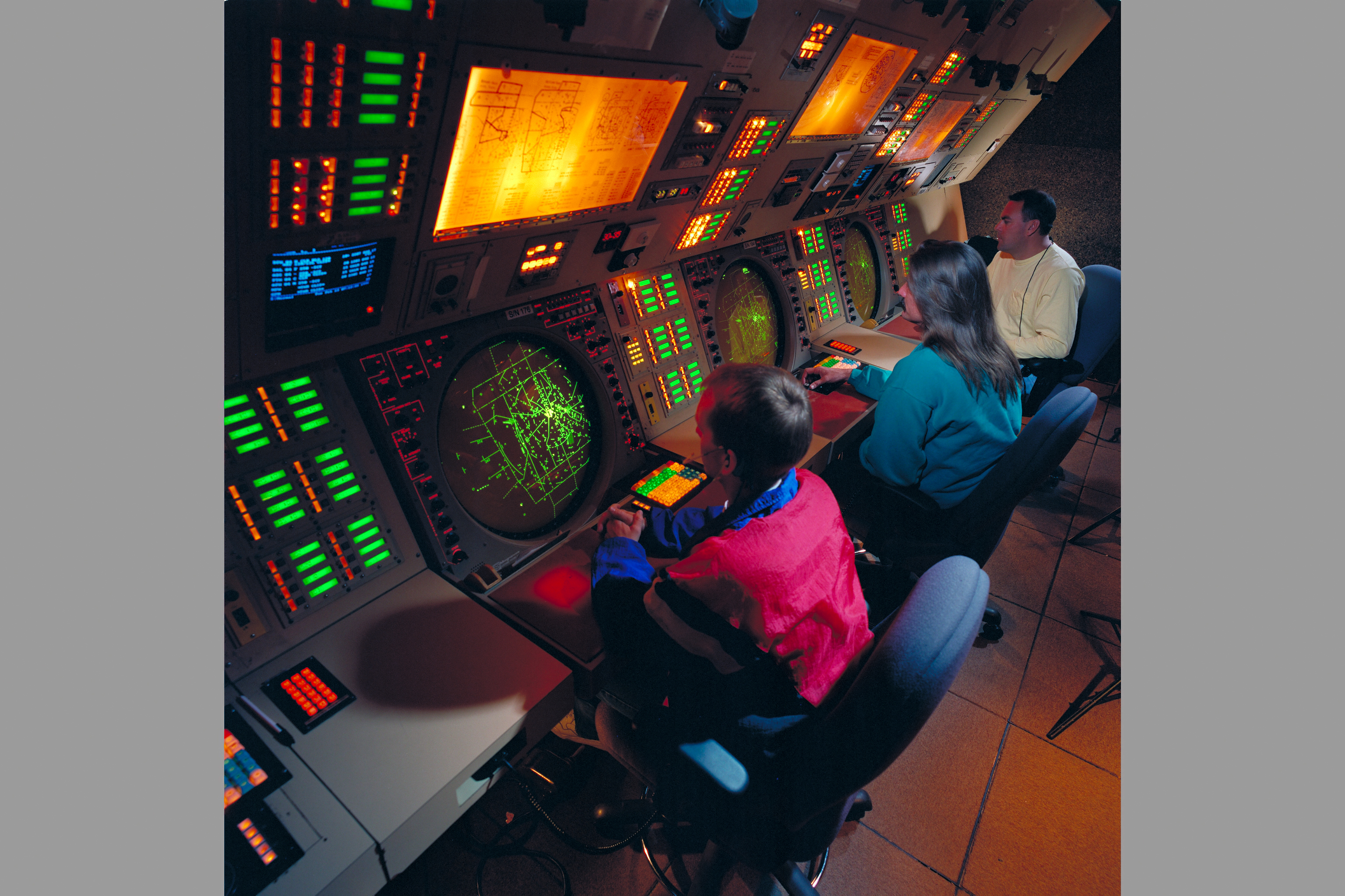
Ikhana piloting, system management, and FAA coordination were accomplished by the Dryden team members in the ground control station alongside the Ames team members, who monitored the AMS systems and wildfire imagery collection.
Photo courtesy Brent Cobleigh
Vince’s team at Ames focused their efforts in three main technology areas. The first was an advanced infrared line scanner capable of seeing through smoke and measuring the temperature on the ground with a resolution less than 1 degree. The system also included an onboard, real-time geo-rectification algorithm that combined the aircraft’s position and orientation to align the measured imagery with a three-dimensional terrain map. The second technology was a Collaborative Decision Environment that allowed fire command teams to rapidly overlay the measured infrared imagery, weather information, satellite data, and other information onto a Google Earth 3–D terrain map. The third technology focused on how to get the autonomously corrected imagery from the unmanned aircraft to the fire command teams in the shortest possible time, ideally less than ten minutes. Up to now, wildfire incident command teams had to wait until the imaging aircraft completed its mission before the imagery could be transmitted.
In parallel with the Ames work, our team at Dryden focused on establishing the initial Ikhana flight operations and planning an unprecedented set of unmanned aircraft flight operations. The Dryden team had to complete the development of a mobile command center that integrated the pilot station with research-monitoring stations, satellite antenna systems, and fiber-optically connected command antennas near the runway. Several aircraft modifications were also required, including the integration of the under-wing AMS sensor pod, installation of instrumentation, and wiring systems.
The Western States Fire Missions challenged the Dryden team to accomplish something that had never been done before: high-altitude (20,000+ ft.), long-duration (twenty hours or more), unmanned aircraft operations in the national airspace (airspace that is not segregated for military use), covering the entire western United States from the Pacific Ocean to Colorado and from the Mexican border to the Canadian border. We needed to be prepared to launch a mission to wherever the highest-priority wildfires might be located and do it within the national airspace, where regulations on how to safely operate unmanned aircraft have yet to be written.
Through previous work with less-ambitious unmanned aircraft operations, the Dryden team had some experience—not all of it the good kind—that informed us what risk mitigation we needed to please the Federal Aviation Administration (FAA) and our own Dryden Airworthiness and Flight Safety Review Board. We developed a fault tree to identify all the possible contributors to a loss of life, either in the air or on the ground, and used that information to focus our risk-mitigation strategies.
In order to protect the public on the ground and the aircraft itself, the project identified more than 300 potential sites where Ikhana could divert in the event an emergency landing was required. The FAA restricted us from performing an emergency landing with Ikhana at public airports, so the project team identified abandoned runways, dry lakebeds, farm fields, and, in some cases, remote terrain to either land the aircraft or crash it safely away from the public. A book containing satellite photos of the 300 sites along with important information on the quality of the site was compiled and kept in the mission control center during all flights. The Dryden range safety office carefully defined the moderate to heavy population centers in the western United States that were declared no-fly zones during the missions. The project team also increased the number of batteries in the aircraft to allow up to three hours of flight time in case of an electrical system failure. In most situations, this would give Ikhana enough time to come back to Dryden or divert to one of two military fields that had agreed to allow emergency landings. The team also developed a moving map display that overlaid Ikhana’s position and satellite weather information on traditional aviation navigation maps so the pilots would have sufficient information to manage the mission.
The Dryden operations team worked closely with the FAA’s Unmanned Aircraft Systems Program Office and air traffic controllers from all affected areas to come up with acceptable mission plans that culminated in the issuance of a Certificate of Authorization (COA) that permitted these unmanned aircraft operations in the national airspace. With the COA in hand, the multiagency Western States Fire Mission team was able to complete four long-duration wildfire-mapping missions in August and September 2007.
After significant air traffic control rerouting around dangerous thunderstorms over Nevada, the second flight mapped wildfires as far from Dryden as Idaho, Montana, and Wyoming. The longest mission lasted twenty hours and covered more than 3,200 miles. Along the route, Ikhana conducted high-resolution infrared mapping of up to eleven wildfires, passing the position-corrected imagery to fire commanders within minutes of acquisition. Our USDA Forest Service partners sent experts to some of the incident commands to help interpret the advanced imagery and instruct them on the use of the Collaborative Decision Environment.
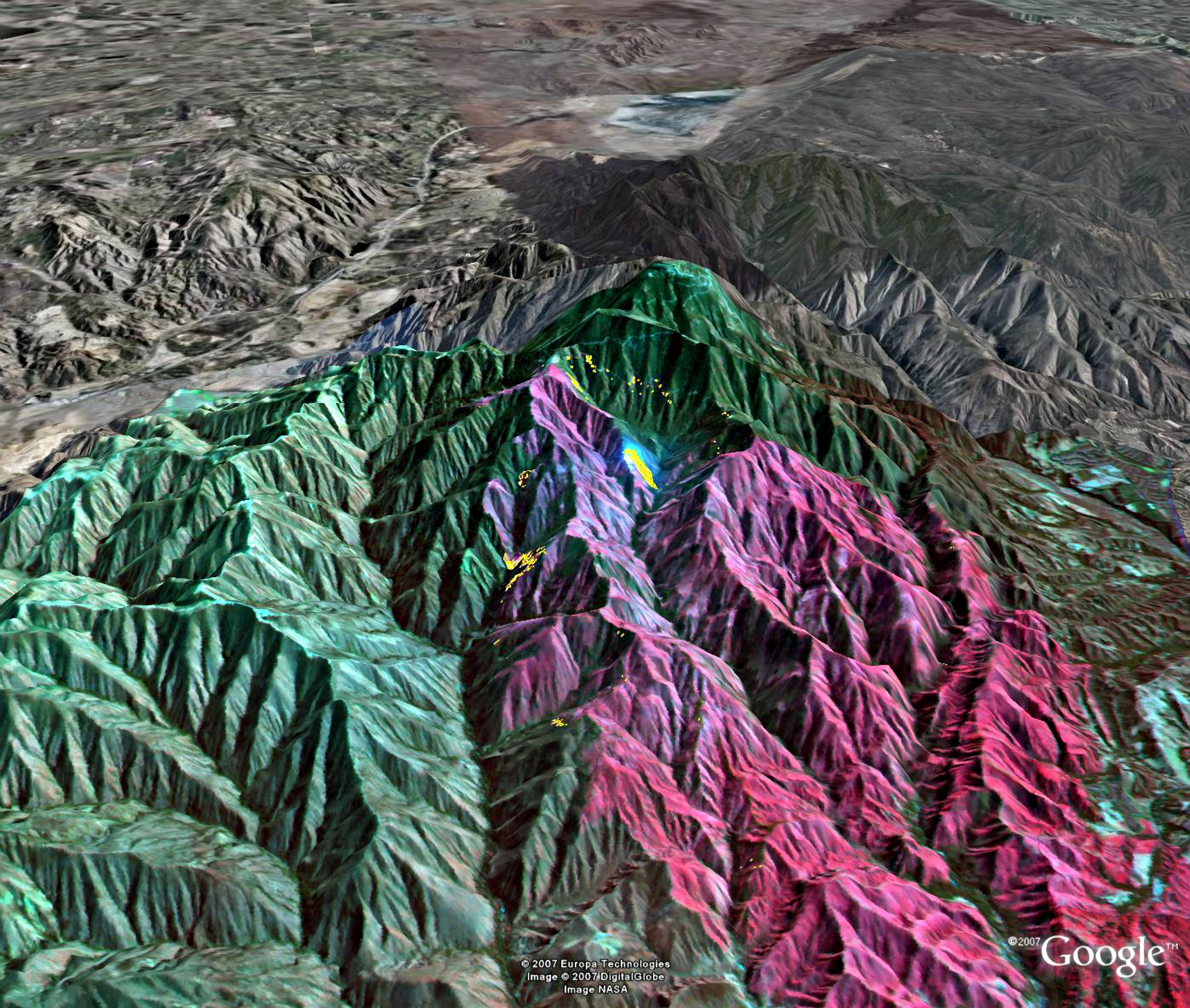
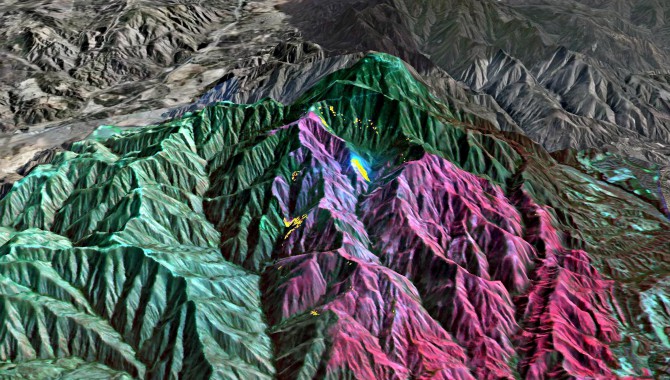
Imagery of the Santiago fire in the mountains of Orange County is draped over a 3–D Google Earth terrain map showing the active fire (yellow), previously burned areas (red), and unburned areas (green).
Image Credit: NASA
The response from the fire commanders on the ground was immediate. The imagery was extremely useful for both strategic and tactical deployment of resources to combat the wildfires. In one case the incident commander credited the near real-time imagery with stopping the deployment of firefighters to a dangerous position between the massive Zaca fire and a secondary fire that was to that point unknown due to the rough mountainous terrain and the smoke. In another case, the imagery uncovered an unknown fire front (8 miles long) that was headed toward the town of Ojai. They immediately dispatched a team to light an 8-mile-long backfire to intercept the new fire. The Ventura County fire chief was emphatic that we had a great tool.
After the September 27 mission, Vince declared the Western States Fire Mission complete, having met or surpassed all its objectives. Over the next three weeks, the multiagency team reviewed data and caught up on well-deserved sleep. Back at Dryden, we began Ikhana modifications for the next flight experiment.
Responding to the Crisis
On Monday, October 23, it became clear that Ikhana needed to respond to the Southern California wildfire emergency, and I pulled together a team to identify and implement a quick method to patch the wing modifications that had been started. Simultaneously, Vince and Everett spun up the Ames and Forest Service teams and began deploying them to Southern California. The FAA quickly granted us an emergency extension to our COA that allowed us to fly within 10 miles of the Mexican border. By midday, we received a request from the California Governor’s Office of Emergency Services to use Ikhana for airborne wildfire imagery. A day later, after fixing a failed hard drive in the AMS imager, Ikhana took off for a nine-hour mission that imaged ten major wildfires across five counties. We continued to follow our range safety rules by flying up to, but not over, the populated area boundaries. We relied on the AMS sensor’s capabilities to image 3 miles to the sides of the aircraft, allowing us to collect imagery where the wildfire had traveled through canyons and into neighborhoods.
Over five days, Ikhana flew a total of four nine-hour flights. These missions imaged wildfires that surrounded the highly populated areas of the Los Angeles basin and multiple areas surrounding San Diego. Near real-time imagery and streaming video was delivered through the aircraft’s satellite link to wildfire incident commanders, the California Emergency Operations Center, Air Force Northern Command, and the Federal Emergency Management Agency (which also paid for several of the flights). Close cooperation with these agencies resulted in changes to imaging priorities while Ikhana was in flight. The cooperation and coordination with FAA to make these flights occur was outstanding. Because of a declared state of emergency, air traffic control gave Ikhana flight priority in the congested Southern California airspace.
The 2007 Western States Fire Missions received multiple NASA Group Achievement Awards and the Association of Unmanned Vehicle Systems International’s Operations Award. From my perspective, the success of the project was due to many factors. The first was the decision to build a strong and lasting partnership between the technology developers (NASA) and the technology users (USDA Forest Service, Bureau of Land Management, and others). This partnership was as strong during the requirements phase as during the operations phase.
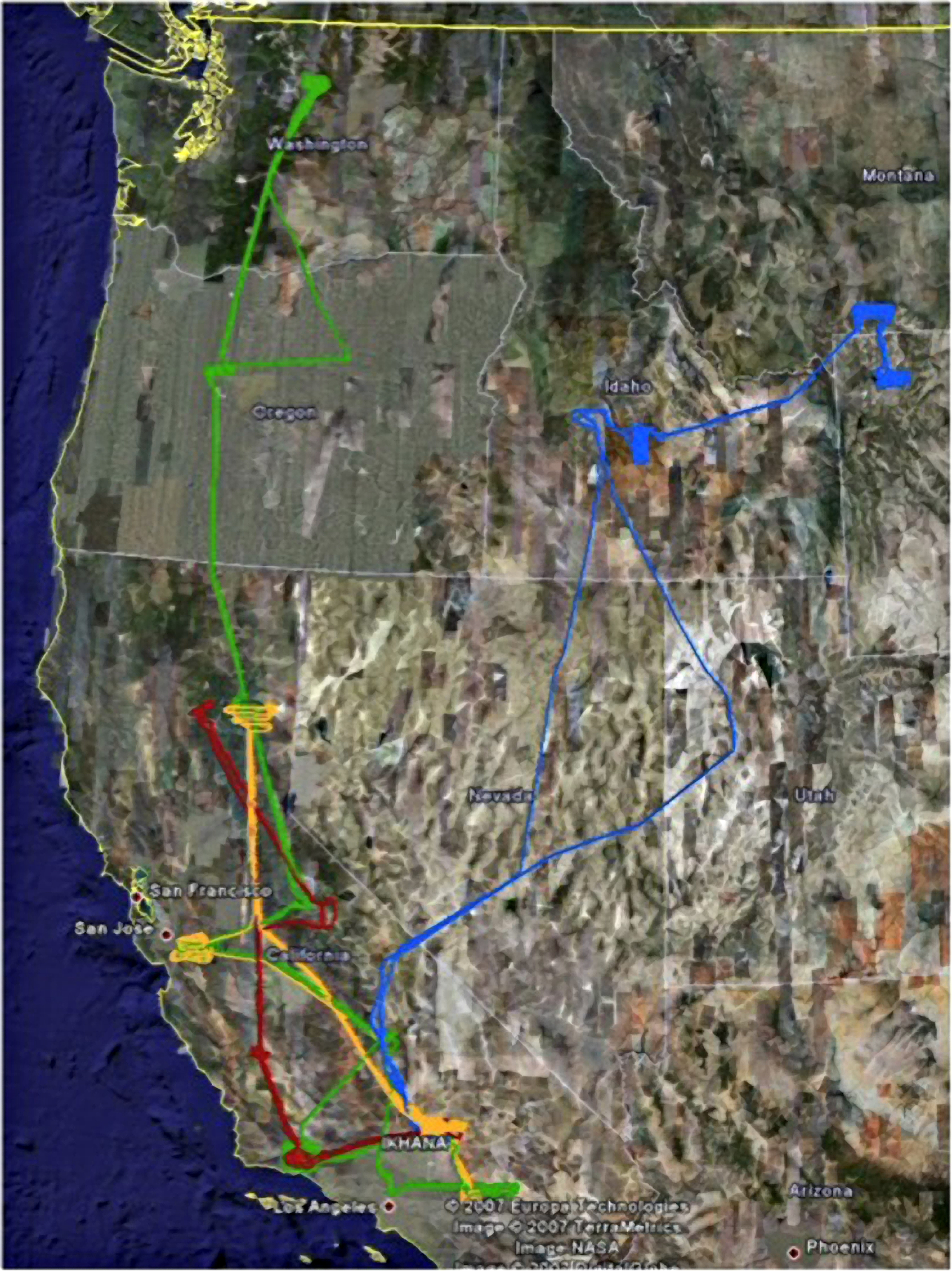
Ikhana flight paths flown during the four 2007 Western States Fire Missions.
Image Credit: NASA
The second success factor was pulling together organizations with expertise in each of the disciplines required by the project and giving each full responsibility for their contribution. The Ames team focused on the wildfire sensor system, automated data processing, networking, and mission priorities. The Dryden team led the aircraft integration, flight operations (with help from General Atomics), and mission safety. The Forest Service focused on the prioritization of the wildfire resources, the needs of fire incident commanders, and interpretation of the imagery.
The third factor was keeping the entire team focused on the goal. From day one, every member of the multiagency team had the same goal: demonstrating the utility of a long-duration unmanned aircraft system outfitted with an advanced infrared imager on the management of wildfires. Staying focused on this goal helped strip away the “nice to haves” from the absolute requirements. The project team would have prized additional science sensors on the aircraft, improved Collaborative Decision Environment capabilities, or added flexibility in the FAA-approved mission plans, but not at the expense of taking imagery of snow-covered mountains (as we often joked) because we were six months late for the fire season.
I look back at the Western States Fire Missions as one of the highlights of my career, not just because of the project’s successes, but also due to the chance to work with some of the most talented and dedicated public servants.
About the Author
 |
Brent Cobleigh was the project manager for the Ikhana unmanned aircraft system, from procurement through initial flight operations. He currently serves as the Exploration Mission Director at Dryden Flight Research Center. |