

![]()
By Melissa Pandika
Tucked in the northeastern corner of California, Surprise Valley is set amid a high desert landscape dotted with hot springs and dry lakebeds. During the first two weeks of September 2012, a team of scientists and engineers collected magnetic data using ground surveys and an unmanned serial system, or UAS, to map the geophysics of Surprise Valley, revealing features buried below the surface.
Although some faults and fractures are visible, some remain hidden underground. And even when researchers know where hot springs are located, they want to understand how fluids flow through the network of underground pores and channels.
Investigating this geothermal fluid-circulation system includes identifying faults below the surface that might conduct the hot mixture of fluids and minerals found in the hot springs. These faults also have the potential to rupture during an earthquake. The detailed studies will help refine predictions of how likely and how damaging earthquakes could be in the region.
The U.S. Geological Survey (USGS)-led, NASA-funded project, which includes a second field session scheduled for next year, will produce a 3-D map that provides geophysical data at a level of detail yet to be achieved for the area. The Surprise Valley community and municipal government can also use the map to inform land and water use decisions, since toxic water zones have been identified, as well to help tap the geothermal system as a sustainable energy source.
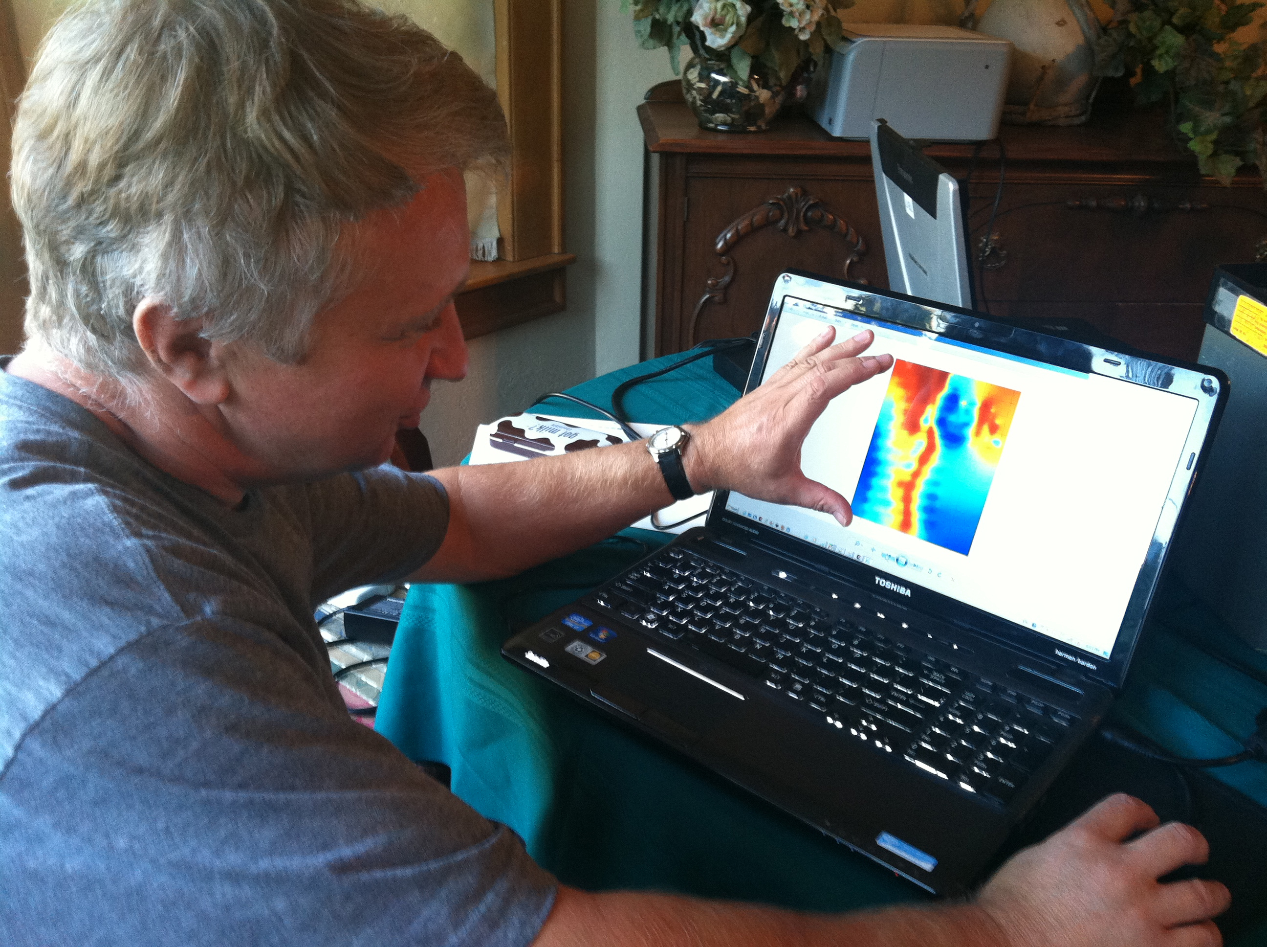
Geometrics engineer Misha Tchernychev displays a magnetic map of the 30-km magnetic anomaly based on raw data before applying the correct fluxgate calibration. While the edges of this image appear blurry, when Misha applied the correct calibration, its resolution improved significantly.
Photo Credit: Melissa Pandika
The team includes scientists and engineers from USGS, Ames Research Center, Central Washington University, and Carnegie Mellon University. Over the years, they’ve collected a wealth of magnetic data by foot and using small all-terrain vehicles. But the areas they can safely survey on the ground are limited. They can’t walk through private lands, dense vegetation, or hot springs, for example.
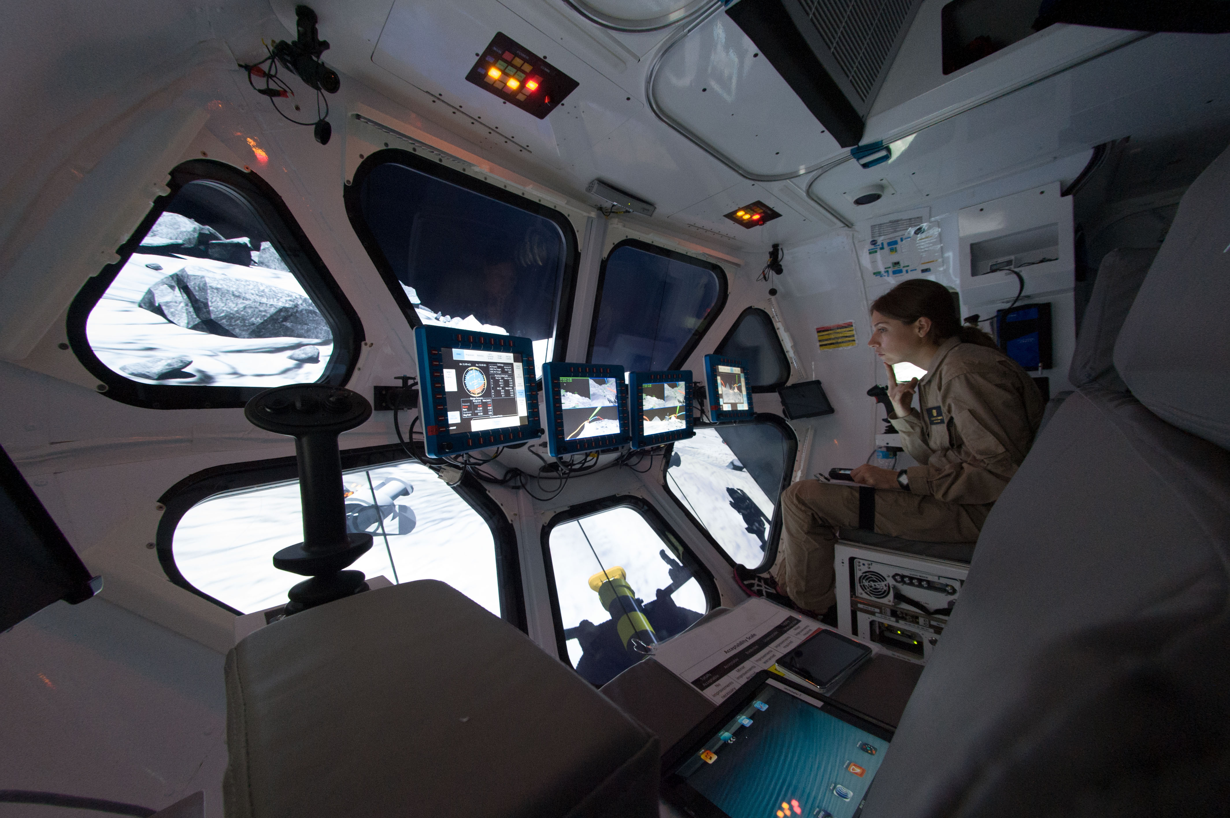
Geoscientists have typically addressed this challenge by hiring pilots to collect data along a specified flight path. Not only are these manned aerial surveys costly, they require pilots to fly at dangerously low altitudes. That’s why the Surprise Valley team has collected data with a small, lightweight UAS known as SIERRA (Sensor Integrated Environmental Remote Research Aircraft). While flying along a preprogrammed path, the NASA-developed SIERRA relays data collected by a magnetometer in its wing to a ground-station computer.
Smoothing Out the Kinks
The first day of an expedition is typically the most hectic. The Surprise Valley team encountered its fair share of issues to troubleshoot.
After the first flight, the wireless communication system set up to download the flight parameter and magnetic data from SIERRA malfunctioned. The team had earlier discussed transferring data directly through a network cable, but with the wireless system, the engineers could avoid directly accessing the aircraft’s sensitive instruments. It turned out the wireless system could not withstand SIERRA’s vibrations during the flight test. With the wireless system down, the payload team developed a workaround that required the aircraft to be physically tethered to the ground station to download data after each flight.
Meanwhile, the compensation data from SIERRA’s fluxgate magnetometer, which takes into account variations in magnetic fields and their direction, yielded highly unusual results. The data from a test of the fluxgate when it was first installed looked reasonable to the team, with variations not far from expected values. They noticed some anomalies, which they believed they could solve only by recalibrating the instrument or remounting it away from magnetic noise, either of which would be prohibitively expensive. The researchers hoped the remoteness of Surprise Valley, away from steel-framed buildings, electric lines, and other magnetic sources, would enable them to perform more precise calibrations to correct for aircraft-related noise.
At the end of the day, the science group—USGS geophysicist and project lead scientist Jonathan Glen, Ames researcher and project lead scientist Corey Ippolito, Carnegie Mellon University researcher Ritchie Lee, and Geometrics engineer Misha Tchernychev—spent hours poring over the compensation data, trying to pinpoint the source of the anomalies. Then an idea occurred to them: maybe the problem was limited only to the fluxgate and not dependent on the aircraft, which they could confirm by examining just the fluxgate in the house. If working properly, the fluxgate’s measurements should closely reflect Earth’s magnetic field, a known value. If they didn’t, then the problem must be due to the fluxgate itself.
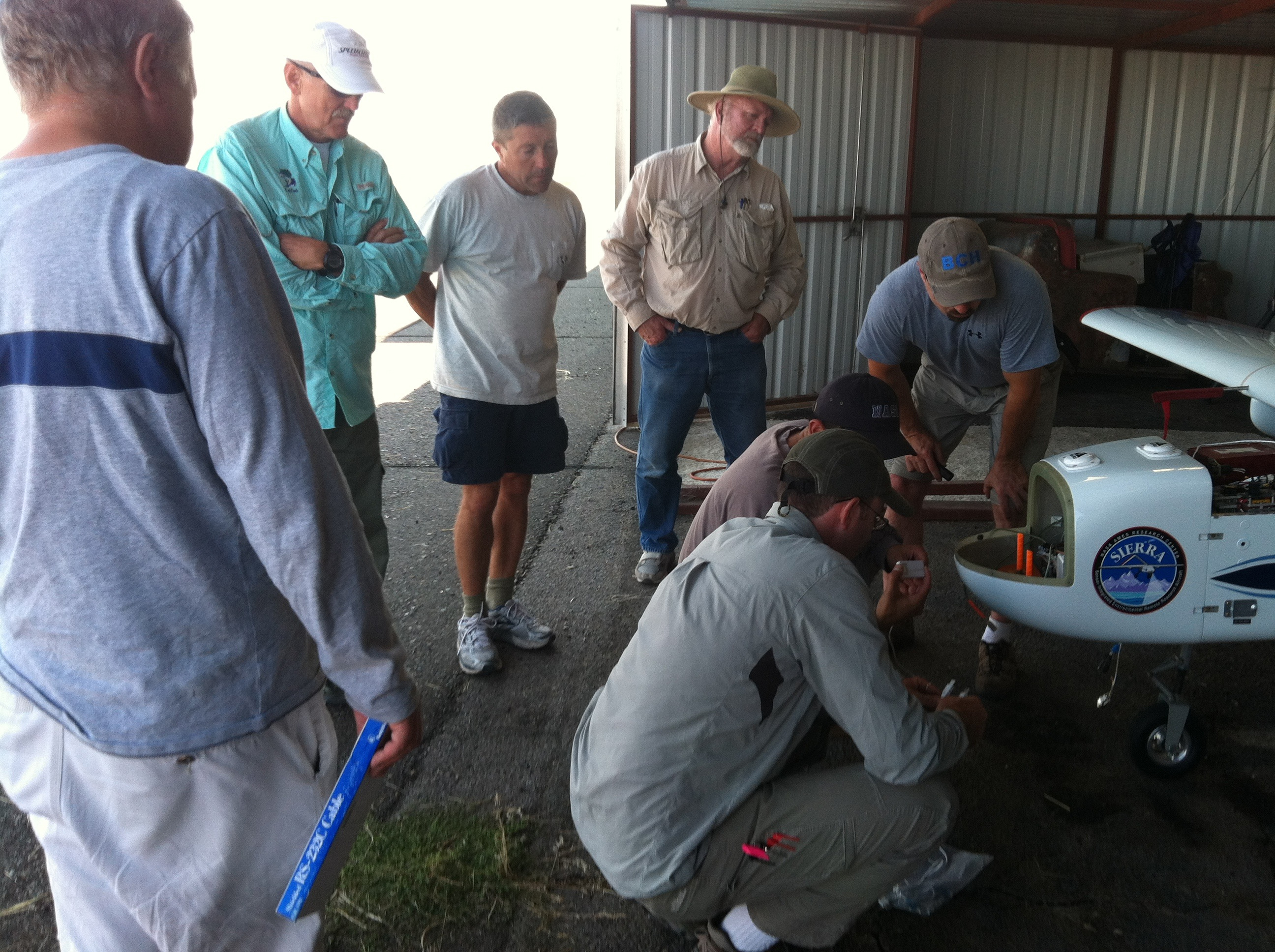
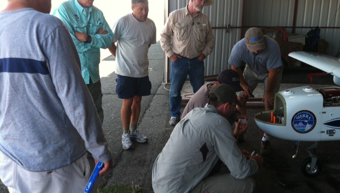
Project co-principal investigator Jonathan Glen (lower left) with NASA and Geometrics engineers, troubleshooting SIERRA’s malfunctioned wireless system. With the wireless system down, the payload team developed a workaround that requires the aircraft to be physically tethered to the ground station to download the data after each flight.
Photo Credit: Melissa Pandika
The SIERRA crew removed the fluxgate magnetometer instrument from the aircraft and provided it to the science group, who took it home for a long night of troubleshooting.
The science group camped out with the fluxgate magnetometer in the dining room, exhausted yet still talking and joking animatedly. After a few hours, the team discovered that the fluxgate could collect data in two modes—calibrated or raw. The fluxgate was currently in calibrated mode. When the team took measurements in this mode, they saw magnetic field values far from those of Earth. When they switched the instrument to raw mode, they saw the values they expected. Clearly the fluxgate’s calibration needed fixing.
Valley of Surprises
Another engineer from Geometrics said he could provide them with a new, properly calibrated fluxgate. He agreed to drop it off at a halfway point, in Redding. Meanwhile, Misha and Jonathan would determine the correct calibration themselves by recording the magnetic field strength and direction the fluxgate magnetometer measured as they moved it through a series of maneuvers. This would yield the mathematical relationship between the raw and improperly calibrated versions of the data, allowing them to convert yesterday’s data to raw data. The measurements would also enable Jonathan and Misha to determine the correct calibration, which they could then apply to the raw data from the first flight day.
They spent the entire morning on the front lawn, one maneuvering the instrument while the other jotted down instrument readings on a sheet of paper. Misha then fed the readings into a computer program to generate an equation reflecting the relationship between the raw and incorrectly calibrated versions of the data. He then applied the equation to the data from the first flight.
The resulting raw data appeared as a magnetic map, showing an array of colors from bright pink to deep purple, reflecting positive and negative magnetic anomalies, respectively, resulting from magnetic sources below the surface. Jonathan pored over the map displayed on the laptop throughout the afternoon, every now and then gathering the other USGS researchers around his screen. Meanwhile, Misha holed up at Cedarville Airport, calculating the correct calibration from the maneuvers earlier. He returned a few hours later with the correct calibration applied to the raw data. While the magnetic map based on the raw data was mostly clear, the edges appeared blurry. When Misha applied the correct calibration, the resolution of the map image improved significantly. Because the entire feature was completely buried, the team wouldn’t have known about it without geophysical mapping. The airborne data provided uniform spatial-data coverage, allowing them to map the feature in fine detail.
Looking at the data, Jonathan spotted a magnetic anomaly continuing along the same direction as an anomaly he and Anne Egger of Central Washington University had mapped when they performed a previous ground-based survey of the area. So far, the data hints that the feature may represent a single structure, but the team can’t draw any conclusions before SIERRA completes the map.
Knowing whether or not the feature is continuous is important, since the magnitude of an earthquake that can occur along a fault is determined primarily by its length. The longer the fault, the larger the earthquake it causes when it ruptures. A continuous fault also means a continuous channel for geothermal fluids, a dangerous scenario, since a hazardous groundwater zone high in mineral content sits in the middle of the feature. Knowing the feature’s structure will help refine predictions of how likely and how damaging earthquakes could be in the region.
As Jonathan continued to navigate through the data, two USGS researchers returned with the new fluxgate, which they handed off to the NASA engineers. That evening, they installed the instrument so SIERRA could fly first thing in the morning.
How a Radio Transmitter Is Like a Funnel
The next day the team felt confident that SIERRA would have a successful flight. But within minutes of takeoff, SIERRA began slowly losing magnetic data. The rate of data loss climbed until the ground base station completely lost the signal from the fluxgate.
Puzzlingly, the UAS had no problem transmitting the fluxgate data while the aircraft was grounded. The team probed the scientific instrumentation for loose cables that might be preventing transmission, conducted an inspection of the aircraft installation, and analyzed the instrument data logs that were recorded during the aborted flight test. Though glassy-eyed, they sounded upbeat as they discussed the issue among themselves, feeling the solution just within reach.
The team’s analysis showed that the replacement fluxgate magnetometer was sending messages at a much higher rate than expected. Eventually, they deduced that the new fluxgate magnetometer instrument was misconfigured in the field for the flight test; it was configured to record samples at a much higher rate than it could transmit to the rest of the data system in real time.
Despite the technical hurdles, SIERRA not only completed its mission one day early, it collected extra data from a largely unexplored region, accelerating the teams understanding of the geophysics of the valley.
SIERRA crew engineer Ric Kolyer likened the issue to pouring water through a funnel. The amount of water that can flow through a funnel is limited by the size of the funnel hole. If water is poured into the funnel faster than the funnel can drain it, the funnel will overflow. Likewise, the fluxgate was sending data to the radio faster than the radio could send it to the ground station. The data overflowed, failing to reach the ground station.
The team reasoned that they didn’t have trouble communicating with SIERRA when it was grounded because they hadn’t allowed it to run long enough. Using Ric’s analogy, water initially flows through a funnel even when it’s poured too quickly. Only after the funnel is filled does it start overflowing. Likewise, while SIERRA was aloft, the team initially saw magnetic data being transmitted via the radio link. They didn’t begin losing data until several minutes later.
Having pinpointed the problem, the team reconfigured the fluxgate magnetometer’s sampling rate, enabling it to sustain communication with the ground base station. SIERRA was ready to fly again.
“Are We Really Done?”
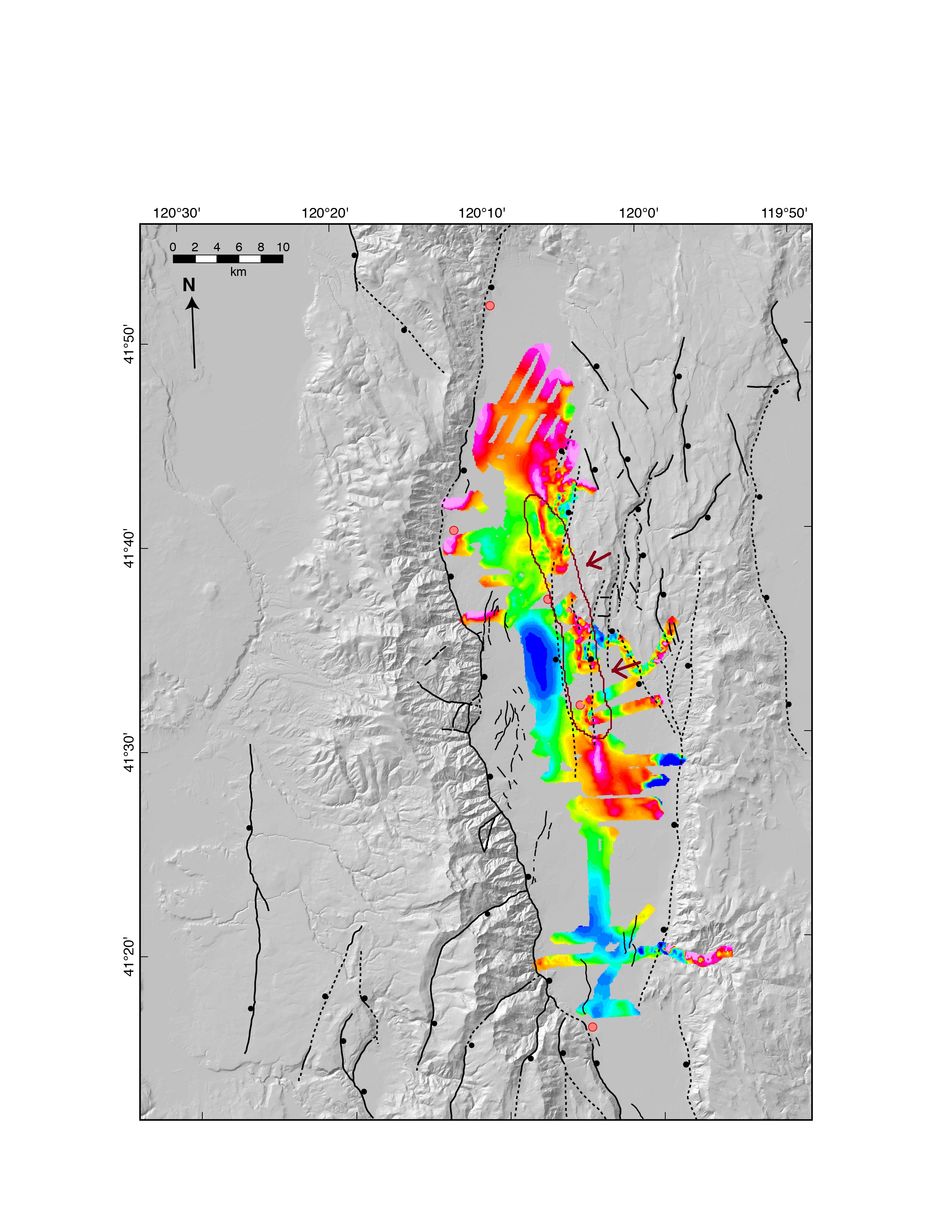
Magnetic anomaly (red line circled in brown) stretching more than 30 km through Surprise Valley, which the team detected during previous ground-based surveys of the area. They hope SIERRA’s surveys will allow them to fill in the gaps on their map (arrows).
Image Credit: Melissa Pandika
The next morning, SIERRA flew smoothly through its survey of the north central detailed region and perimeter of Surprise Valley. With time to spare, SIERRA lead engineer Randy Berthold agreed to USGS researchers’ requests for a detailed survey of a southern region the following day in addition to the broad survey across the entire valley they had originally planned. Despite the technical hurdles, SIERRA not only completed its mission one day early, it collected extra data from a largely unexplored region, accelerating the team’s understanding of the geophysics of the valley.
“Are we really done? After all that work?” Corey asked on SIERRA’s last night in Surprise Valley. “Can’t we just fly the plane ten more times?”
On the afternoon of SIERRA’s last flight day, Jonathan drove with Central Washington University geologist and project lead scientist Anne to the east side of the valley to pick up USGS researcher Noah Athens, who had been collecting magnetic data by foot. As they stepped out of the car, they spotted SIERRA directly overhead.
“It was an amazing moment,” said Anne. “We both realized that everything we had been working on for a year and a half was working. It was so satisfying, and so remarkable to feel like we were in the middle of a success. After all the troubleshooting, we really felt good about where we were.”
Note: This story was originally published in a series of NASA blog entries, which can be found at blogs.nasa.gov/cm/newui/blog/viewpostlist.jsp?blogname=mission-ames.
Related Links
About the Author
 Melissa Pandika is a journalism master’s student at Stanford University. Previously, she studied molecular and cell biology at the University of California-Berkeley and investigated how highly aggressive brain tumors evade therapies that block blood vessel growth at the University of California-San Francisco. You can follow her on twitter, @mmpandika. Melissa Pandika is a journalism master’s student at Stanford University. Previously, she studied molecular and cell biology at the University of California-Berkeley and investigated how highly aggressive brain tumors evade therapies that block blood vessel growth at the University of California-San Francisco. You can follow her on twitter, @mmpandika. |